Corral de Piedra geodata
Corral de Piedra (Oaxaca) is a populated place; located in Mexico in America/Mexico_City (GMT-6) time zone. With population of 1,066 people, there are 8182 cities with bigger population in this country. Compared to other cities in Mexico, 75.6% of cities are located further ↑North; 80.8% of cities are located further ←West and 82.9% of cities have higher elevation than Corral de Piedra. Note1


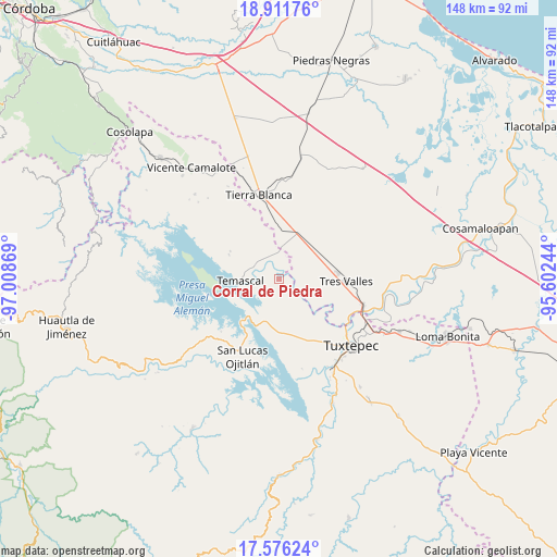
Corral de Piedra GPS coordinates[2]
18° 14' 43.008" North, 96° 18' 20.016" West
| Map corner | latitude | longitude |
|---|---|---|
| Upper-left | 18.91176°, | -97.00869° |
| Center: | 18.24528°, | -96.30556° |
| Lower-right: | 17.57624°, | -95.60244° |
| Map W x H: | 148.5×148.5 km | = 92.3×92.3mi |
| max Lat: | 32.7° ⇑75.6% North |
| Corral de Piedra: | 18.24528° |
| min Lat: | ⇓24.4% South 14.53588° |
| min Long | Corral de Piedr | max Long |
| -117.105° | -96.30556° | -86.73105° |
| W 80.8%⇐ | ⇒19.2% E |
Elevation
Elevation of Corral de Piedra is 61 m = 200 ft, and this is 1192.7 m = 3913 ft below average elevation for this country.
| Max E: |
3497 m = 11473 ft | 82.9% |
| Avg. | 1253.7 m = 4113 ft | |
| Corral de Piedra | 61 m = 200 ft | |
Min E: |
-1 m = -3 ft | 17.1% |
See also: Mexico elevation on elevation.city.
Geographical zone
Corral de Piedra is located in North Torrid zone (between Equator and Tropic of Cancer). Distance of this Northern Tropic circle is 577.2 km =358.7 mi to North.| Distance of | km | miles | from Corral de Piedra |
|---|---|---|---|
| North Pole | 7978.4 | 4957.5 | to North |
| Arctic Circle | 5372.5 | 3338.3 | to North |
| Tropic Cancer | 577.2 | 358.7 | to North |
| Equator | 2028.7 | 1260.6 | to South |


Nearby cities:
15 places around Corral de Piedra: (largest is in red/bold)
• Arroyo Chical (Nuevo Arroyo Chicali)
4.6 km =2.9 mi,  225°
225°
• Buenos Aires el Apompo
11.4 km =7.1 mi,  171°
171°
• Cerro Tepezcuintle
11.6 km =7.2 mi,  199°
199°
• El Capulín (La Nueva Pochota)
3.4 km =2.1 mi,  120°
120°
• El Encajonado
8.6 km =5.3 mi,  266°
266°
• El Nuevo Manantial
8.7 km =5.4 mi,  74°
74°
• La Reforma
6.6 km =4.1 mi,  350°
350°
• La Reforma
6.9 km =4.3 mi,  333°
333°
• Las Margaritas
2.5 km =1.6 mi,  64°
64°
• Nuevo Paso Nacional
9.6 km =6 mi, 268°
• Nuevo Paso Nazareno (Chichicazapa)
7.2 km =4.5 mi,  322°
322°
• Nuevo Pescadito de Abajo
5.1 km =3.2 mi,  260°
260°
• Nuevo Pescadito de Enmedio
8.2 km =5.1 mi,  290°
290°
• Paso Rincón
2.8 km =1.7 mi,  35°
35°
• Temascal
10.2 km =6.3 mi, 268°
Sources, notices
• [Note1] Compared only with cities in Mexico existing in our database
• [Src1] Map data: © OpenStreetMap contributors (CC-BY-SA)
• [Src2] Other city data from geonames.org with taken over terms of usage.
• [Src3] Geographical zone / Annual Mean Temperature by Robert A. Rohde @ Wikipedia
