Zarzal geodata
Zarzal (Oaxaca) is a populated place; located in Mexico in America/Mexico_City (GMT-6) time zone. With population of 1,022 people, there are 8517 cities with bigger population in this country. Compared to other cities in Mexico, 88.7% of cities are located further ↑North; 84.5% of cities are located further ←West and 79.1% of cities have higher elevation than Zarzal. Note1


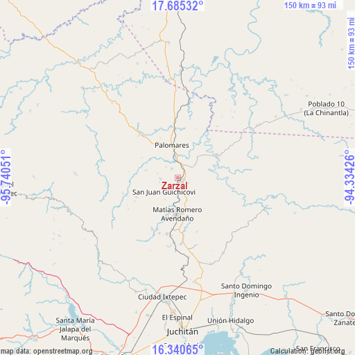
Zarzal GPS coordinates[2]
17° 0' 51.084" North, 95° 2' 14.568" West
| Map corner | latitude | longitude |
|---|---|---|
| Upper-left | 17.68532°, | -95.74051° |
| Center: | 17.01419°, | -95.03738° |
| Lower-right: | 16.34065°, | -94.33426° |
| Map W x H: | 149.5×149.5 km | = 92.9×92.9mi |
| max Lat: | 32.7° ⇑88.7% North |
| Zarzal: | 17.01419° |
| min Lat: | ⇓11.3% South 14.53588° |
| min Long | Zarzal | max Long |
| -117.105° | -95.03738° | -86.73105° |
| W 84.5%⇐ | ⇒15.5% E |
Elevation
Elevation of Zarzal is 109 m = 358 ft, and this is 1144.7 m = 3756 ft below average elevation for this country.
| Max E: |
3497 m = 11473 ft | 79.1% |
| Avg. | 1253.7 m = 4113 ft | |
| Zarzal | 109 m = 358 ft | |
Min E: |
-1 m = -3 ft | 20.9% |
See also: Mexico elevation on elevation.city.
Geographical zone
Zarzal is located in North Torrid zone (between Equator and Tropic of Cancer). Distance of this Northern Tropic circle is 714.1 km =443.7 mi to North.| Distance of | km | miles | from Zarzal |
|---|---|---|---|
| North Pole | 8115.3 | 5042.6 | to North |
| Arctic Circle | 5509.4 | 3423.4 | to North |
| Tropic Cancer | 714.1 | 443.7 | to North |
| Equator | 1891.8 | 1175.5 | to South |


Nearby cities:
15 places around Zarzal: (largest is in red/bold)
• Barreña
11.7 km =7.3 mi,  137°
137°
• Boca del Monte
5.8 km =3.6 mi,  22°
22°
• Colonia Rincón Viejo
14.2 km =8.8 mi,  184°
184°
• El Bajío
13.9 km =8.6 mi, 179°
• El Chocolate
10.7 km =6.6 mi,  211°
211°
• Encinal Colorado
7.5 km =4.7 mi,  266°
266°
• Estación Mogoñé
2.2 km =1.4 mi, 178°
• Mogoñé Viejo
1.5 km =0.9 mi,  126°
126°
• Nuevo Progreso
13.9 km =8.6 mi,  354°
354°
• Palomares
14.1 km =8.8 mi, 348°
• Paso Real de Sarabia
6.7 km =4.2 mi, 351°
• Piedra Blanca
3.9 km =2.4 mi, 137°
• Río Pachiñe
5.9 km =3.7 mi, 210°
• San Juan Guichicovi
8.4 km =5.2 mi,  226°
226°
• Santa Ana
6.8 km =4.2 mi,  311°
311°
Sources, notices
• [Note1] Compared only with cities in Mexico existing in our database
• [Src1] Map data: © OpenStreetMap contributors (CC-BY-SA)
• [Src2] Other city data from geonames.org with taken over terms of usage.
• [Src3] Geographical zone / Annual Mean Temperature by Robert A. Rohde @ Wikipedia
