Zitlán geodata
Zitlán (Hidalgo) is a populated place; located in Mexico in America/Mexico_City (GMT-6) time zone. With population of 609 people, there are 14153 cities with bigger population in this country. Compared to other cities in Mexico, 78.8% of cities are located further ↓South; 57.5% of cities are located further ←West and 77.2% of cities have higher elevation than Zitlán. Note1


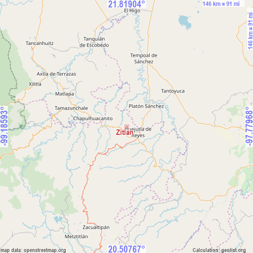
Zitlán GPS coordinates[2]
21° 9' 53.316" North, 98° 28' 58.08" West
| Map corner | latitude | longitude |
|---|---|---|
| Upper-left | 21.81904°, | -99.18593° |
| Center: | 21.16481°, | -98.4828° |
| Lower-right: | 20.50767°, | -97.77968° |
| Map W x H: | 145.8×145.8 km | = 90.6×90.6mi |
| max Lat: | 32.7° ⇑21.2% North |
| Zitlán: | 21.16481° |
| min Lat: | ⇓78.8% South 14.53588° |
| min Long | Zitlán | max Long |
| -117.105° | -98.4828° | -86.73105° |
| W 57.5%⇐ | ⇒42.5% E |
Elevation
Elevation of Zitlán is 148 m = 486 ft, and this is 1105.7 m = 3628 ft below average elevation for this country.
| Max E: |
3497 m = 11473 ft | 77.2% |
| Avg. | 1253.7 m = 4113 ft | |
| Zitlán | 148 m = 486 ft | |
Min E: |
-1 m = -3 ft | 22.8% |
See also: Mexico elevation on elevation.city.
Geographical zone
Zitlán is located in North Torrid zone (between Equator and Tropic of Cancer). Distance of this Northern Tropic circle is 252.6 km =157 mi to North.| Distance of | km | miles | from Zitlán |
|---|---|---|---|
| North Pole | 7653.8 | 4755.8 | to North |
| Arctic Circle | 5047.9 | 3136.6 | to North |
| Tropic Cancer | 252.6 | 157 | to North |
| Equator | 2353.3 | 1462.3 | to South |


Nearby cities:
15 places around Zitlán: (largest is in red/bold)
• Acoapa
4.9 km =3 mi,  185°
185°
• Aquixcuatitla
6.3 km =3.9 mi,  169°
169°
• Chililico
5.9 km =3.7 mi,  124°
124°
• Contepec
3.4 km =2.1 mi, 194°
• Hueynali
3.4 km =2.1 mi, 124°
• La Capilla
4.6 km =2.9 mi,  251°
251°
• La Curva Tlaltzintla
5.1 km =3.2 mi,  142°
142°
• Macustepetla
4.7 km =2.9 mi,  177°
177°
• Panacaxtlán
3.4 km =2.1 mi, 121°
• Santa Cruz
3.9 km =2.4 mi,  342°
342°
• Tancazahuela
5.4 km =3.4 mi,  67°
67°
• Tepexititla
5.2 km =3.2 mi,  134°
134°
• Xocotitla
4.3 km =2.7 mi, 188°
• Zapotitla
5.4 km =3.4 mi, 133°
• Ámaxac
5.7 km =3.5 mi,  5°
5°
Sources, notices
• [Note1] Compared only with cities in Mexico existing in our database
• [Src1] Map data: © OpenStreetMap contributors (CC-BY-SA)
• [Src2] Other city data from geonames.org with taken over terms of usage.
• [Src3] Geographical zone / Annual Mean Temperature by Robert A. Rohde @ Wikipedia
