Panacaxtlán geodata
Panacaxtlán (Hidalgo) is a populated place; located in Mexico in America/Mexico_City (GMT-6) time zone. With population of 859 people, there are 10183 cities with bigger population in this country. Compared to other cities in Mexico, 78.5% of cities are located further ↓South; 57.9% of cities are located further ←West and 75% of cities have higher elevation than Panacaxtlán. Note1


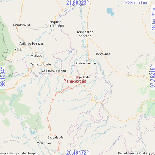
Panacaxtlán GPS coordinates[2]
21° 8' 56.148" North, 98° 27' 18.972" West
| Map corner | latitude | longitude |
|---|---|---|
| Upper-left | 21.80323°, | -99.1584° |
| Center: | 21.14893°, | -98.45527° |
| Lower-right: | 20.49172°, | -97.75215° |
| Map W x H: | 145.8×145.8 km | = 90.6×90.6mi |
| max Lat: | 32.7° ⇑21.5% North |
| Panacaxtlán: | 21.14893° |
| min Lat: | ⇓78.5% South 14.53588° |
| min Long | Panacaxtlán | max Long |
| -117.105° | -98.45527° | -86.73105° |
| W 57.9%⇐ | ⇒42.1% E |
Elevation
Elevation of Panacaxtlán is 222 m = 728 ft, and this is 1031.7 m = 3385 ft below average elevation for this country.
| Max E: |
3497 m = 11473 ft | 75% |
| Avg. | 1253.7 m = 4113 ft | |
| Panacaxtlán | 222 m = 728 ft | |
Min E: |
-1 m = -3 ft | 25% |
See also: Mexico elevation on elevation.city.
Geographical zone
Panacaxtlán is located in North Torrid zone (between Equator and Tropic of Cancer). Distance of this Northern Tropic circle is 254.4 km =158.1 mi to North.| Distance of | km | miles | from Panacaxtlán |
|---|---|---|---|
| North Pole | 7655.5 | 4756.9 | to North |
| Arctic Circle | 5049.6 | 3137.7 | to North |
| Tropic Cancer | 254.4 | 158.1 | to North |
| Equator | 2351.5 | 1461.2 | to South |


Nearby cities:
15 places around Panacaxtlán: (largest is in red/bold)
• Acoapa
4.5 km =2.8 mi,  226°
226°
• Aguacatitla
4.1 km =2.5 mi,  169°
169°
• Aquixcuatitla
4.8 km =3 mi,  201°
201°
• Chililico
2.6 km =1.6 mi,  128°
128°
• Contepec
4 km =2.5 mi,  247°
247°
• El Pintor
4.5 km =2.8 mi,  75°
75°
• Huejutla de Reyes
3.8 km =2.4 mi,  104°
104°
• Hueynali
0.2 km =0.1 mi,  214°
214°
• La Curva Tlaltzintla
2.2 km =1.4 mi, 173°
• Macustepetla
3.9 km =2.4 mi,  222°
222°
• Tancazahuela
4.3 km =2.7 mi,  29°
29°
• Tepexititla
2 km =1.2 mi,  156°
156°
• Xocotitla
4.3 km =2.7 mi, 234°
• Zapotitla
2.2 km =1.4 mi,  151°
151°
• Zitlán
3.4 km =2.1 mi,  301°
301°
Sources, notices
• [Note1] Compared only with cities in Mexico existing in our database
• [Src1] Map data: © OpenStreetMap contributors (CC-BY-SA)
• [Src2] Other city data from geonames.org with taken over terms of usage.
• [Src3] Geographical zone / Annual Mean Temperature by Robert A. Rohde @ Wikipedia
