Taxadho geodata
Taxadho (Hidalgo) is a populated place; located in Mexico in America/Mexico_City (GMT-6) time zone. With population of 1,417 people, there are 6099 cities with bigger population in this country. Compared to other cities in Mexico, 66.4% of cities are located further ↓South; 51.8% of cities are located further →East and 64.3% of cities have lower elevation than Taxadho. Note1


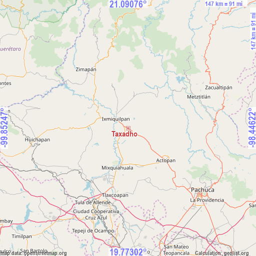
Taxadho GPS coordinates[2]
20° 25' 59.88" North, 99° 8' 57.624" West
| Map corner | latitude | longitude |
|---|---|---|
| Upper-left | 21.09076°, | -99.85247° |
| Center: | 20.4333°, | -99.14934° |
| Lower-right: | 19.77302°, | -98.44622° |
| Map W x H: | 146.5×146.5 km | = 91×91mi |
| max Lat: | 32.7° ⇑33.6% North |
| Taxadho: | 20.4333° |
| min Lat: | ⇓66.4% South 14.53588° |
| min Long | Taxadho | max Long |
| -117.105° | -99.14934° | -86.73105° |
| W 48.2%⇐ | ⇒51.8% E |
Elevation
Elevation of Taxadho is 1809 m = 5935 ft, and this is 555.3 m = 1822 ft above average elevation for this country.
| Max E: |
3497 m = 11473 ft | 35.7% |
| Taxadho | 1809 m 5935 ft | |
| Avg. | 1253.7 m = 4113 ft | |
Min E: |
-1 m = -3 ft | 64.3% |
See also: Mexico elevation on elevation.city.
Geographical zone
Taxadho is located in North Torrid zone (between Equator and Tropic of Cancer). Distance of this Northern Tropic circle is 333.9 km =207.5 mi to North.| Distance of | km | miles | from Taxadho |
|---|---|---|---|
| North Pole | 7735.1 | 4806.4 | to North |
| Arctic Circle | 5129.2 | 3187.1 | to North |
| Tropic Cancer | 333.9 | 207.5 | to North |
| Equator | 2272 | 1411.8 | to South |


Nearby cities:
15 places around Taxadho: (largest is in red/bold)
• Bangandhó
5.5 km =3.4 mi,  0°
0°
• Cantinela
6.9 km =4.3 mi,  293°
293°
• Cañada Chica
2.3 km =1.4 mi,  196°
196°
• Colonia el Mirador
7.1 km =4.4 mi,  350°
350°
• Dios Padre
6.4 km =4 mi,  302°
302°
• El Barrido
4.7 km =2.9 mi, 293°
• El Mejay
6.3 km =3.9 mi,  212°
212°
• El Tablón
4.3 km =2.7 mi,  249°
249°
• El Tephé
3.2 km =2 mi, 302°
• El Xothi
4.1 km =2.5 mi,  216°
216°
• Ex- Hacienda de Ocotza
5.7 km =3.5 mi,  98°
98°
• Julián Villagrán
6.2 km =3.9 mi,  131°
131°
• Maguey Blanco
2.4 km =1.5 mi,  243°
243°
• Pueblo Nuevo
3 km =1.9 mi,  323°
323°
• Xuchitlán
5 km =3.1 mi,  183°
183°
Sources, notices
• [Note1] Compared only with cities in Mexico existing in our database
• [Src1] Map data: © OpenStreetMap contributors (CC-BY-SA)
• [Src2] Other city data from geonames.org with taken over terms of usage.
• [Src3] Geographical zone / Annual Mean Temperature by Robert A. Rohde @ Wikipedia
