Teocalco geodata
Teocalco (Hidalgo) is a populated place; located in Mexico in America/Mexico_City (GMT-6) time zone. With population of 1,123 people, there are 7722 cities with bigger population in this country. Compared to other cities in Mexico, 58.8% of cities are located further ↓South; 54% of cities are located further →East and 77.5% of cities have lower elevation than Teocalco. Note1


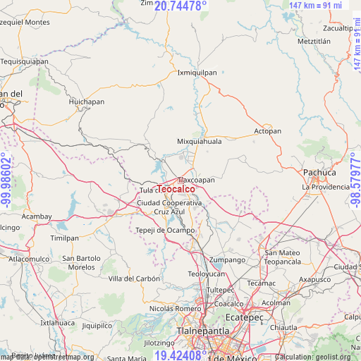
Teocalco GPS coordinates[2]
20° 5' 8.952" North, 99° 16' 58.404" West
| Map corner | latitude | longitude |
|---|---|---|
| Upper-left | 20.74478°, | -99.98602° |
| Center: | 20.08582°, | -99.28289° |
| Lower-right: | 19.42408°, | -98.57977° |
| Map W x H: | 146.8×146.8 km | = 91.2×91.2mi |
| max Lat: | 32.7° ⇑41.2% North |
| Teocalco: | 20.08582° |
| min Lat: | ⇓58.8% South 14.53588° |
| min Long | Teocalco | max Long |
| -117.105° | -99.28289° | -86.73105° |
| W 46%⇐ | ⇒54% E |
Elevation
Elevation of Teocalco is 2078 m = 6818 ft, and this is 824.3 m = 2704 ft above average elevation for this country.
| Max E: |
3497 m = 11473 ft | 22.5% |
| Teocalco | 2078 m 6818 ft | |
| Avg. | 1253.7 m = 4113 ft | |
Min E: |
-1 m = -3 ft | 77.5% |
See also: Mexico elevation on elevation.city.
Geographical zone
Teocalco is located in North Torrid zone (between Equator and Tropic of Cancer). Distance of this Northern Tropic circle is 372.6 km =231.5 mi to North.| Distance of | km | miles | from Teocalco |
|---|---|---|---|
| North Pole | 7773.7 | 4830.4 | to North |
| Arctic Circle | 5167.8 | 3211.1 | to North |
| Tropic Cancer | 372.6 | 231.5 | to North |
| Equator | 2233.3 | 1387.7 | to South |


Nearby cities:
15 places around Teocalco: (largest is in red/bold)
• Atitalaquia
7 km =4.3 mi,  114°
114°
• Bomintzha
8.1 km =5 mi,  172°
172°
• Cardonal
6.4 km =4 mi,  120°
120°
• Colonia Benito Juárez
6.4 km =4 mi,  290°
290°
• Colonia Lázaro Cárdenas
7.9 km =4.9 mi,  33°
33°
• Doxey
4.2 km =2.6 mi,  80°
80°
• El Llano
4.5 km =2.8 mi,  239°
239°
• Residencial Arboledas
3.1 km =1.9 mi,  219°
219°
• Santa Ana Ahuehuepan
7.7 km =4.8 mi,  302°
302°
• Tlahuelilpan
7.3 km =4.5 mi,  47°
47°
• Tlalminulpa
6.5 km =4 mi,  100°
100°
• Tlamaco (San Gerónimo Tlamaco)
8 km =5 mi,  135°
135°
• Tlaxcoapan
6.6 km =4.1 mi, 84°
• Tula de Allende
7.4 km =4.6 mi, 239°
• Unidad Habitacional Antonio Osorio de León (Bojay)
6.1 km =3.8 mi, 139°
Sources, notices
• [Note1] Compared only with cities in Mexico existing in our database
• [Src1] Map data: © OpenStreetMap contributors (CC-BY-SA)
• [Src2] Other city data from geonames.org with taken over terms of usage.
• [Src3] Geographical zone / Annual Mean Temperature by Robert A. Rohde @ Wikipedia
