Munitepec de Madero geodata
Munitepec de Madero (Hidalgo) is a populated place; located in Mexico in America/Mexico_City (GMT-6) time zone. With population of 2,520 people, there are 3515 cities with bigger population in this country. Compared to other cities in Mexico, 59.7% of cities are located further ↓South; 52.8% of cities are located further →East and 79.6% of cities have lower elevation than Munitepec de Madero. Note1


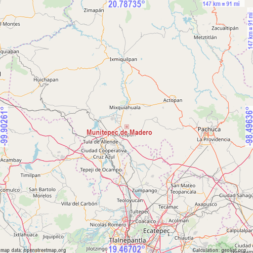
Munitepec de Madero GPS coordinates[2]
20° 7' 42.888" North, 99° 11' 58.128" West
| Map corner | latitude | longitude |
|---|---|---|
| Upper-left | 20.78735°, | -99.90261° |
| Center: | 20.12858°, | -99.19948° |
| Lower-right: | 19.46702°, | -98.49636° |
| Map W x H: | 146.8×146.8 km | = 91.2×91.2mi |
| max Lat: | 32.7° ⇑40.3% North |
| Munitepec de Madero: | 20.12858° |
| min Lat: | ⇓59.7% South 14.53588° |
| min Long | Munitepec de Ma | max Long |
| -117.105° | -99.19948° | -86.73105° |
| W 47.2%⇐ | ⇒52.8% E |
Elevation
Elevation of Munitepec de Madero is 2129 m = 6985 ft, and this is 875.3 m = 2872 ft above average elevation for this country.
| Max E: |
3497 m = 11473 ft | 20.4% |
| Munitepec de Madero | 2129 m 6985 ft | |
| Avg. | 1253.7 m = 4113 ft | |
Min E: |
-1 m = -3 ft | 79.6% |
See also: Mexico elevation on elevation.city.
Geographical zone
Munitepec de Madero is located in North Torrid zone (between Equator and Tropic of Cancer). Distance of this Northern Tropic circle is 367.8 km =228.5 mi to North.| Distance of | km | miles | from Munitepec de Madero |
|---|---|---|---|
| North Pole | 7769 | 4827.4 | to North |
| Arctic Circle | 5163.1 | 3208.2 | to North |
| Tropic Cancer | 367.8 | 228.5 | to North |
| Equator | 2238.1 | 1390.7 | to South |


Nearby cities:
15 places around Munitepec de Madero: (largest is in red/bold)
• Atitalaquia
8 km =5 mi,  196°
196°
• Cañada
5.3 km =3.3 mi,  11°
11°
• Colonia Lázaro Cárdenas
4.7 km =2.9 mi,  292°
292°
• Colonia Teñhe
7.5 km =4.7 mi,  16°
16°
• Doxey
6.2 km =3.9 mi,  228°
228°
• La Cruz
6.9 km =4.3 mi,  320°
320°
• Mangas
8.2 km =5.1 mi, 321°
• Motovatha
6.2 km =3.9 mi,  354°
354°
• Presas
6.5 km =4 mi,  301°
301°
• Teltipán de Juárez
1.5 km =0.9 mi,  187°
187°
• Tetepango
5.9 km =3.7 mi,  120°
120°
• Tezoquipa
8 km =5 mi,  183°
183°
• Tlahuelilpan
3.3 km =2.1 mi,  274°
274°
• Tlalminulpa
6.4 km =4 mi, 201°
• Tlaxcoapan
4.7 km =2.9 mi,  208°
208°
Sources, notices
• [Note1] Compared only with cities in Mexico existing in our database
• [Src1] Map data: © OpenStreetMap contributors (CC-BY-SA)
• [Src2] Other city data from geonames.org with taken over terms of usage.
• [Src3] Geographical zone / Annual Mean Temperature by Robert A. Rohde @ Wikipedia
