Cañada geodata
Cañada (Hidalgo) is a populated place; located in Mexico in America/Mexico_City (GMT-6) time zone. With population of 1,183 people, there are 7346 cities with bigger population in this country. Compared to other cities in Mexico, 60.8% of cities are located further ↓South; 52.6% of cities are located further →East and 74.8% of cities have lower elevation than Cañada. Note1


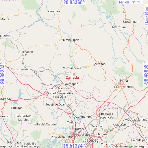
Cañada GPS coordinates[2]
20° 10' 30.396" North, 99° 11' 22.92" West
| Map corner | latitude | longitude |
|---|---|---|
| Upper-left | 20.83368°, | -99.89283° |
| Center: | 20.17511°, | -99.1897° |
| Lower-right: | 19.51374°, | -98.48658° |
| Map W x H: | 146.8×146.8 km | = 91.2×91.2mi |
| max Lat: | 32.7° ⇑39.2% North |
| Cañada: | 20.17511° |
| min Lat: | ⇓60.8% South 14.53588° |
| min Long | Cañada | max Long |
| -117.105° | -99.1897° | -86.73105° |
| W 47.4%⇐ | ⇒52.6% E |
Elevation
Elevation of Cañada is 2026 m = 6647 ft, and this is 772.3 m = 2534 ft above average elevation for this country.
| Max E: |
3497 m = 11473 ft | 25.2% |
| Cañada | 2026 m 6647 ft | |
| Avg. | 1253.7 m = 4113 ft | |
Min E: |
-1 m = -3 ft | 74.8% |
See also: Mexico elevation on elevation.city.
Geographical zone
Cañada is located in North Torrid zone (between Equator and Tropic of Cancer). Distance of this Northern Tropic circle is 362.7 km =225.4 mi to North.| Distance of | km | miles | from Cañada |
|---|---|---|---|
| North Pole | 7763.8 | 4824.2 | to North |
| Arctic Circle | 5157.9 | 3205 | to North |
| Tropic Cancer | 362.7 | 225.4 | to North |
| Equator | 2243.3 | 1393.9 | to South |


Nearby cities:
15 places around Cañada: (largest is in red/bold)
• Arbol Grande
4.7 km =2.9 mi,  20°
20°
• Colonia Lázaro Cárdenas
6.3 km =3.9 mi,  237°
237°
• Colonia Morelos (El Nueve)
7.5 km =4.7 mi,  42°
42°
• Colonia Teñhe
2.3 km =1.4 mi,  30°
30°
• La Cruz
5.4 km =3.4 mi,  271°
271°
• La Loma
7.7 km =4.8 mi, 271°
• Mangas
6.2 km =3.9 mi,  281°
281°
• Mixquiahuala de Juarez
6.6 km =4.1 mi,  337°
337°
• Motovatha
1.9 km =1.2 mi,  300°
300°
• Munitepec de Madero
5.3 km =3.3 mi,  191°
191°
• Palmillas
4.9 km =3 mi,  349°
349°
• Presas
6.8 km =4.2 mi,  255°
255°
• Progreso de Alvaro Obregon
8.2 km =5.1 mi,  359°
359°
• Teltipán de Juárez
6.8 km =4.2 mi, 190°
• Tlahuelilpan
6.6 km =4.1 mi,  221°
221°
Sources, notices
• [Note1] Compared only with cities in Mexico existing in our database
• [Src1] Map data: © OpenStreetMap contributors (CC-BY-SA)
• [Src2] Other city data from geonames.org with taken over terms of usage.
• [Src3] Geographical zone / Annual Mean Temperature by Robert A. Rohde @ Wikipedia
