Tetepango geodata
Tetepango (Hidalgo) is a populated place; located in Mexico in America/Mexico_City (GMT-6) time zone. With population of 8,705 people, there are 1095 cities with bigger population in this country. Compared to other cities in Mexico, 59.2% of cities are located further ↓South; 51.9% of cities are located further →East and 78.5% of cities have lower elevation than Tetepango. Note1


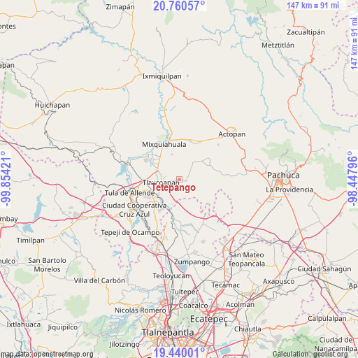
Tetepango GPS coordinates[2]
20° 6' 6.048" North, 99° 9' 3.888" West
| Map corner | latitude | longitude |
|---|---|---|
| Upper-left | 20.76057°, | -99.85421° |
| Center: | 20.10168°, | -99.15108° |
| Lower-right: | 19.44001°, | -98.44796° |
| Map W x H: | 146.8×146.8 km | = 91.2×91.2mi |
| max Lat: | 32.7° ⇑40.8% North |
| Tetepango: | 20.10168° |
| min Lat: | ⇓59.2% South 14.53588° |
| min Long | Tetepango | max Long |
| -117.105° | -99.15108° | -86.73105° |
| W 48.1%⇐ | ⇒51.9% E |
Elevation
Elevation of Tetepango is 2100 m = 6890 ft, and this is 846.3 m = 2777 ft above average elevation for this country.
| Max E: |
3497 m = 11473 ft | 21.5% |
| Tetepango | 2100 m 6890 ft | |
| Avg. | 1253.7 m = 4113 ft | |
Min E: |
-1 m = -3 ft | 78.5% |
See also: Mexico elevation on elevation.city.
Geographical zone
Tetepango is located in North Torrid zone (between Equator and Tropic of Cancer). Distance of this Northern Tropic circle is 370.8 km =230.4 mi to North.| Distance of | km | miles | from Tetepango |
|---|---|---|---|
| North Pole | 7772 | 4829.3 | to North |
| Arctic Circle | 5166.1 | 3210.1 | to North |
| Tropic Cancer | 370.8 | 230.4 | to North |
| Equator | 2235.1 | 1388.8 | to South |


Nearby cities:
15 places around Tetepango: (largest is in red/bold)
• Ajacuba
3.2 km =2 mi,  110°
110°
• Atitalaquia
8.7 km =5.4 mi,  237°
237°
• Cardonal
9.7 km =6 mi, 238°
• Cañada
9.1 km =5.7 mi,  333°
333°
• Colonia Lázaro Cárdenas
10.5 km =6.5 mi,  296°
296°
• Colonia Teñhe
10.5 km =6.5 mi,  344°
344°
• Doxey
9.7 km =6 mi,  263°
263°
• Munitepec de Madero
5.9 km =3.7 mi, 300°
• Santiago Tezontlale
8.7 km =5.4 mi,  39°
39°
• Teltipán de Juárez
5.5 km =3.4 mi,  286°
286°
• Texas
9.7 km =6 mi,  208°
208°
• Tezoquipa
7.5 km =4.7 mi,  228°
228°
• Tlahuelilpan
9 km =5.6 mi, 291°
• Tlalminulpa
8 km =5 mi,  248°
248°
• Tlaxcoapan
7.3 km =4.5 mi, 261°
Sources, notices
• [Note1] Compared only with cities in Mexico existing in our database
• [Src1] Map data: © OpenStreetMap contributors (CC-BY-SA)
• [Src2] Other city data from geonames.org with taken over terms of usage.
• [Src3] Geographical zone / Annual Mean Temperature by Robert A. Rohde @ Wikipedia
