Mangas geodata
Mangas (Hidalgo) is a populated place; located in Mexico in America/Mexico_City (GMT-6) time zone. With population of 3,776 people, there are 2424 cities with bigger population in this country. Compared to other cities in Mexico, 61.1% of cities are located further ↓South; 53.6% of cities are located further →East and 73.7% of cities have lower elevation than Mangas. Note1


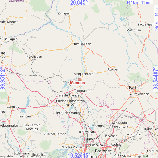
Mangas GPS coordinates[2]
20° 11' 11.292" North, 99° 14' 52.764" West
| Map corner | latitude | longitude |
|---|---|---|
| Upper-left | 20.845°, | -99.95112° |
| Center: | 20.18647°, | -99.24799° |
| Lower-right: | 19.52515°, | -98.54487° |
| Map W x H: | 146.8×146.8 km | = 91.2×91.2mi |
| max Lat: | 32.7° ⇑38.9% North |
| Mangas: | 20.18647° |
| min Lat: | ⇓61.1% South 14.53588° |
| min Long | Mangas | max Long |
| -117.105° | -99.24799° | -86.73105° |
| W 46.4%⇐ | ⇒53.6% E |
Elevation
Elevation of Mangas is 2005 m = 6578 ft, and this is 751.3 m = 2465 ft above average elevation for this country.
| Max E: |
3497 m = 11473 ft | 26.3% |
| Mangas | 2005 m 6578 ft | |
| Avg. | 1253.7 m = 4113 ft | |
Min E: |
-1 m = -3 ft | 73.7% |
See also: Mexico elevation on elevation.city.
Geographical zone
Mangas is located in North Torrid zone (between Equator and Tropic of Cancer). Distance of this Northern Tropic circle is 361.4 km =224.6 mi to North.| Distance of | km | miles | from Mangas |
|---|---|---|---|
| North Pole | 7762.5 | 4823.4 | to North |
| Arctic Circle | 5156.6 | 3204.2 | to North |
| Tropic Cancer | 361.4 | 224.6 | to North |
| Equator | 2244.5 | 1394.7 | to South |


Nearby cities:
15 places around Mangas: (largest is in red/bold)
• Cañada
6.2 km =3.9 mi,  101°
101°
• Colonia Lázaro Cárdenas
4.7 km =2.9 mi,  170°
170°
• Colonia San Juan
3.7 km =2.3 mi,  276°
276°
• Huitel
3.9 km =2.4 mi,  235°
235°
• La Cruz
1.3 km =0.8 mi,  149°
149°
• La Loma
1.9 km =1.2 mi, 238°
• La Palma
3.4 km =2.1 mi,  346°
346°
• Mixquiahuala de Juarez
6 km =3.7 mi,  36°
36°
• Motovatha
4.5 km =2.8 mi,  93°
93°
• Panuaya
2.6 km =1.6 mi,  291°
291°
• Presas
3 km =1.9 mi,  188°
188°
• San Isidro el Tanque
4.3 km =2.7 mi,  252°
252°
• Santa María Batha
4.2 km =2.6 mi, 354°
• Santiago Acayutlán
5.1 km =3.2 mi, 283°
• Tezontepec de Aldama
2.8 km =1.7 mi, 279°
Sources, notices
• [Note1] Compared only with cities in Mexico existing in our database
• [Src1] Map data: © OpenStreetMap contributors (CC-BY-SA)
• [Src2] Other city data from geonames.org with taken over terms of usage.
• [Src3] Geographical zone / Annual Mean Temperature by Robert A. Rohde @ Wikipedia
