Palmillas geodata
Palmillas (Hidalgo) is a populated place; located in Mexico in America/Mexico_City (GMT-6) time zone. With population of 1,910 people, there are 4552 cities with bigger population in this country. Compared to other cities in Mexico, 61.8% of cities are located further ↓South; 52.7% of cities are located further →East and 74% of cities have lower elevation than Palmillas. Note1


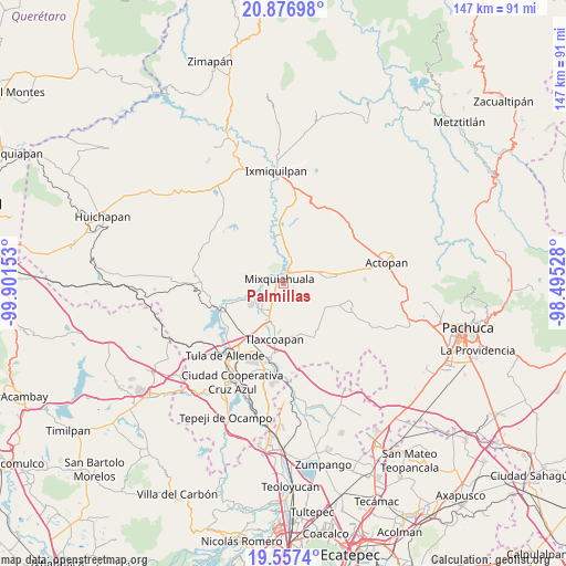
Palmillas GPS coordinates[2]
20° 13' 6.924" North, 99° 11' 54.24" West
| Map corner | latitude | longitude |
|---|---|---|
| Upper-left | 20.87698°, | -99.90153° |
| Center: | 20.21859°, | -99.1984° |
| Lower-right: | 19.5574°, | -98.49528° |
| Map W x H: | 146.7×146.7 km | = 91.2×91.2mi |
| max Lat: | 32.7° ⇑38.2% North |
| Palmillas: | 20.21859° |
| min Lat: | ⇓61.8% South 14.53588° |
| min Long | Palmillas | max Long |
| -117.105° | -99.1984° | -86.73105° |
| W 47.3%⇐ | ⇒52.7% E |
Elevation
Elevation of Palmillas is 2011 m = 6598 ft, and this is 757.3 m = 2485 ft above average elevation for this country.
| Max E: |
3497 m = 11473 ft | 26% |
| Palmillas | 2011 m 6598 ft | |
| Avg. | 1253.7 m = 4113 ft | |
Min E: |
-1 m = -3 ft | 74% |
See also: Mexico elevation on elevation.city.
Geographical zone
Palmillas is located in North Torrid zone (between Equator and Tropic of Cancer). Distance of this Northern Tropic circle is 357.8 km =222.3 mi to North.| Distance of | km | miles | from Palmillas |
|---|---|---|---|
| North Pole | 7759 | 4821.2 | to North |
| Arctic Circle | 5153.1 | 3202 | to North |
| Tropic Cancer | 357.8 | 222.3 | to North |
| Equator | 2248.1 | 1396.9 | to South |


Nearby cities:
15 places around Palmillas: (largest is in red/bold)
• Arbol Grande
2.6 km =1.6 mi,  99°
99°
• Cañada
4.9 km =3 mi,  169°
169°
• Colonia Morelos (El Nueve)
6 km =3.7 mi,  83°
83°
• Colonia Teñhe
3.5 km =2.2 mi,  144°
144°
• Jagüey Blanco
8 km =5 mi,  36°
36°
• La Cruz
6.5 km =4 mi,  223°
223°
• La Loma
8.2 km =5.1 mi,  236°
236°
• La Palma
6 km =3.7 mi,  267°
267°
• Mangas
6.3 km =3.9 mi, 235°
• Mixquiahuala de Juarez
2.1 km =1.3 mi,  308°
308°
• Motovatha
3.9 km =2.4 mi,  190°
190°
• Panuaya
8 km =5 mi,  250°
250°
• Progreso de Alvaro Obregon
3.5 km =2.2 mi,  14°
14°
• Santa María Batha
5.6 km =3.5 mi,  276°
276°
• Tunititlán
5.9 km =3.7 mi, 305°
Sources, notices
• [Note1] Compared only with cities in Mexico existing in our database
• [Src1] Map data: © OpenStreetMap contributors (CC-BY-SA)
• [Src2] Other city data from geonames.org with taken over terms of usage.
• [Src3] Geographical zone / Annual Mean Temperature by Robert A. Rohde @ Wikipedia
