Mixquiahuala de Juarez geodata
Mixquiahuala de Juarez (Hidalgo) is a populated place; located in Mexico in America/Mexico_City (GMT-6) time zone. With population of 25,510 people, there are 398 cities with bigger population in this country. Compared to other cities in Mexico, 62.1% of cities are located further ↓South; 53% of cities are located further →East and 73.6% of cities have lower elevation than Mixquiahuala de Juarez. Note1
Current local time in Mixquiahuala de Juarez:
11:32 AM, TuesdayDifference from your time zone: hours


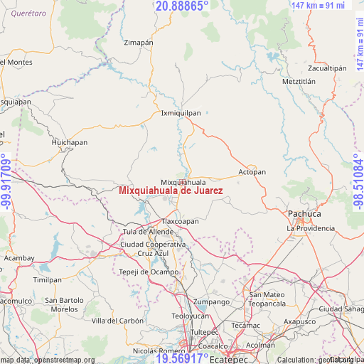
Mixquiahuala de Juarez GPS coordinates[2]
20° 13' 49.116" North, 99° 12' 50.256" West
| Map corner | latitude | longitude |
|---|---|---|
| Upper-left | 20.88865°, | -99.91709° |
| Center: | 20.23031°, | -99.21396° |
| Lower-right: | 19.56917°, | -98.51084° |
| Map W x H: | 146.7×146.7 km | = 91.2×91.2mi |
| max Lat: | 32.7° ⇑37.9% North |
| Mixquiahuala de Juarez: | 20.23031° |
| min Lat: | ⇓62.1% South 14.53588° |
| min Long | Mixquiahuala de | max Long |
| -117.105° | -99.21396° | -86.73105° |
| W 47%⇐ | ⇒53% E |
Elevation
Elevation of Mixquiahuala de Juarez is 2002 m = 6568 ft, and this is 748.3 m = 2455 ft above average elevation for this country.
| Max E: |
3497 m = 11473 ft | 26.4% |
| Mixquiahuala de Juarez | 2002 m 6568 ft | |
| Avg. | 1253.7 m = 4113 ft | |
Min E: |
-1 m = -3 ft | 73.6% |
See also: Mexico elevation on elevation.city.
Geographical zone
Mixquiahuala de Juarez is located in North Torrid zone (between Equator and Tropic of Cancer). Distance of this Northern Tropic circle is 356.5 km =221.5 mi to North.| Distance of | km | miles | from Mixquiahuala de Juarez |
|---|---|---|---|
| North Pole | 7757.7 | 4820.4 | to North |
| Arctic Circle | 5151.8 | 3201.2 | to North |
| Tropic Cancer | 356.5 | 221.5 | to North |
| Equator | 2249.4 | 1397.7 | to South |


Nearby cities:
15 places around Mixquiahuala de Juarez: (largest is in red/bold)
• Arbol Grande
4.5 km =2.8 mi,  112°
112°
• Cañada
6.6 km =4.1 mi,  157°
157°
• Colonia Huitexcalco
7.6 km =4.7 mi,  299°
299°
• Colonia Morelos (El Nueve)
7.6 km =4.7 mi,  94°
94°
• Colonia Teñhe
5.6 km =3.5 mi,  138°
138°
• La Cruz
6.7 km =4.2 mi,  205°
205°
• La Palma
4.6 km =2.9 mi,  250°
250°
• Mangas
6 km =3.7 mi,  216°
216°
• Motovatha
5.3 km =3.3 mi,  169°
169°
• Palmillas
2.1 km =1.3 mi,  128°
128°
• Panuaya
7.1 km =4.4 mi,  236°
236°
• Progreso de Alvaro Obregon
3.3 km =2.1 mi,  49°
49°
• Santa María Batha
4 km =2.5 mi,  260°
260°
• Texcatepec
6.6 km =4.1 mi,  321°
321°
• Tunititlán
3.8 km =2.4 mi, 303°
Sources, notices
• [Note1] Compared only with cities in Mexico existing in our database
• [Src1] Map data: © OpenStreetMap contributors (CC-BY-SA)
• [Src2] Other city data from geonames.org with taken over terms of usage.
• [Src3] Geographical zone / Annual Mean Temperature by Robert A. Rohde @ Wikipedia
