Chimalpa y Tlalayote geodata
Chimalpa y Tlalayote (Hidalgo) is a populated place; located in Mexico in America/Mexico_City (GMT-6) time zone. With population of 2,363 people, there are 3739 cities with bigger population in this country. Compared to other cities in Mexico, 50.6% of cities are located further ↑North; 57.1% of cities are located further ←West and 92% of cities have lower elevation than Chimalpa y Tlalayote. Note1
Current local time in Chimalpa y Tlalayote:
05:31 AM, WednesdayDifference from your time zone: hours


Chimalpa y Tlalayote GPS coordinates[2]
19° 39' 54.792" North, 98° 30' 44.064" West
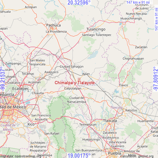
| Map corner | latitude | longitude |
|---|---|---|
| Upper-left | 20.32596°, | -99.21537° |
| Center: | 19.66522°, | -98.51224° |
| Lower-right: | 19.00175°, | -97.80912° |
| Map W x H: | 147.2×147.2 km | = 91.5×91.5mi |
| max Lat: | 32.7° ⇑50.6% North |
| Chimalpa y Tlalayote: | 19.66522° |
| min Lat: | ⇓49.4% South 14.53588° |
| min Long | Chimalpa y Tlal | max Long |
| -117.105° | -98.51224° | -86.73105° |
| W 57.1%⇐ | ⇒42.9% E |
Elevation
Elevation of Chimalpa y Tlalayote is 2483 m = 8146 ft, and this is 1229.3 m = 4033 ft above average elevation for this country.
| Max E: |
3497 m = 11473 ft | 8% |
| Chimalpa y Tlalayote | 2483 m 8146 ft | |
| Avg. | 1253.7 m = 4113 ft | |
Min E: |
-1 m = -3 ft | 92% |
See also: Mexico elevation on elevation.city.
Geographical zone
Chimalpa y Tlalayote is located in North Torrid zone (between Equator and Tropic of Cancer). Distance of this Northern Tropic circle is 419.4 km =260.6 mi to North.| Distance of | km | miles | from Chimalpa y Tlalayote |
|---|---|---|---|
| North Pole | 7820.5 | 4859.4 | to North |
| Arctic Circle | 5214.6 | 3240.2 | to North |
| Tropic Cancer | 419.4 | 260.6 | to North |
| Equator | 2186.6 | 1358.7 | to South |


Nearby cities:
15 places around Chimalpa y Tlalayote: (largest is in red/bold)
• Acopinalco
5.4 km =3.4 mi,  336°
336°
• Apan
8.2 km =5.1 mi,  51°
51°
• Emiliano Zapata
3.6 km =2.2 mi,  251°
251°
• Francisco Villa
10.2 km =6.3 mi,  149°
149°
• José María Morelos (San José)
7 km =4.3 mi,  285°
285°
• La Laguna
7.8 km =4.8 mi,  9°
9°
• Lomas del Pedregal
9.3 km =5.8 mi, 13°
• Los Voladores
2.6 km =1.6 mi, 45°
• Lázaro Cárdenas
5.1 km =3.2 mi,  123°
123°
• Ocotepec
9 km =5.6 mi,  67°
67°
• San Bartolomé Tepetates
9.7 km =6 mi,  329°
329°
• San Juan Ixtilmaco
6.6 km =4.1 mi,  89°
89°
• Santa Bárbara
6 km =3.7 mi,  271°
271°
• Santa Clara
7.8 km =4.8 mi,  298°
298°
• Zotoluca
6.1 km =3.8 mi,  178°
178°
Sources, notices
• [Note1] Compared only with cities in Mexico existing in our database
• [Src1] Map data: © OpenStreetMap contributors (CC-BY-SA)
• [Src2] Other city data from geonames.org with taken over terms of usage.
• [Src3] Geographical zone / Annual Mean Temperature by Robert A. Rohde @ Wikipedia
