Los Voladores geodata
Los Voladores (Hidalgo) is a populated place; located in Mexico in America/Mexico_City (GMT-6) time zone. With population of 533 people, there are 15888 cities with bigger population in this country. Compared to other cities in Mexico, 50.1% of cities are located further ↑North; 57.3% of cities are located further ←West and 92.8% of cities have lower elevation than Los Voladores. Note1


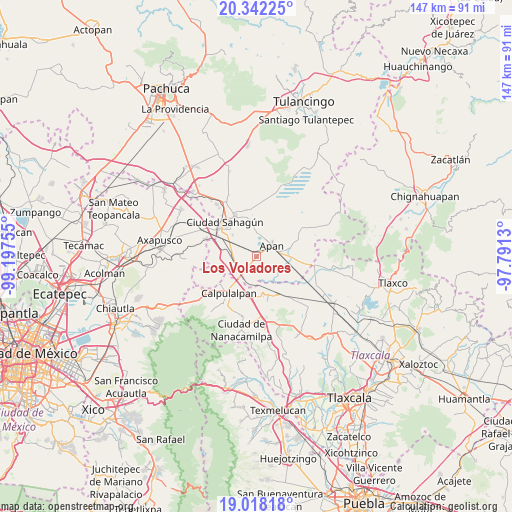
Los Voladores GPS coordinates[2]
19° 40' 53.688" North, 98° 29' 39.912" West
| Map corner | latitude | longitude |
|---|---|---|
| Upper-left | 20.34225°, | -99.19755° |
| Center: | 19.68158°, | -98.49442° |
| Lower-right: | 19.01818°, | -97.7913° |
| Map W x H: | 147.2×147.2 km | = 91.5×91.5mi |
| max Lat: | 32.7° ⇑50.1% North |
| Los Voladores: | 19.68158° |
| min Lat: | ⇓49.9% South 14.53588° |
| min Long | Los Voladores | max Long |
| -117.105° | -98.49442° | -86.73105° |
| W 57.3%⇐ | ⇒42.7% E |
Elevation
Elevation of Los Voladores is 2518 m = 8261 ft, and this is 1264.3 m = 4148 ft above average elevation for this country.
| Max E: |
3497 m = 11473 ft | 7.2% |
| Los Voladores | 2518 m 8261 ft | |
| Avg. | 1253.7 m = 4113 ft | |
Min E: |
-1 m = -3 ft | 92.8% |
See also: Mexico elevation on elevation.city.
Geographical zone
Los Voladores is located in North Torrid zone (between Equator and Tropic of Cancer). Distance of this Northern Tropic circle is 417.5 km =259.4 mi to North.| Distance of | km | miles | from Los Voladores |
|---|---|---|---|
| North Pole | 7818.7 | 4858.3 | to North |
| Arctic Circle | 5212.8 | 3239.1 | to North |
| Tropic Cancer | 417.5 | 259.4 | to North |
| Equator | 2188.4 | 1359.8 | to South |


Nearby cities:
15 places around Los Voladores: (largest is in red/bold)
• Acopinalco
5.1 km =3.2 mi,  307°
307°
• Almoloya
9.8 km =6.1 mi,  75°
75°
• Apan
5.6 km =3.5 mi,  54°
54°
• Chimalpa y Tlalayote
2.6 km =1.6 mi,  225°
225°
• Emiliano Zapata
6.1 km =3.8 mi,  240°
240°
• José María Morelos (San José)
8.6 km =5.3 mi,  270°
270°
• La Laguna
5.9 km =3.7 mi,  354°
354°
• Lomas del Pedregal
7.2 km =4.5 mi,  2°
2°
• Lázaro Cárdenas
5.2 km =3.2 mi,  152°
152°
• Ocotepec
6.6 km =4.1 mi, 75°
• San Bartolomé Tepetates
9.4 km =5.8 mi, 314°
• San Juan Ixtilmaco
5 km =3.1 mi,  110°
110°
• Santa Bárbara
8 km =5 mi,  258°
258°
• Santa Clara
8.9 km =5.5 mi,  282°
282°
• Zotoluca
8.1 km =5 mi,  192°
192°
Sources, notices
• [Note1] Compared only with cities in Mexico existing in our database
• [Src1] Map data: © OpenStreetMap contributors (CC-BY-SA)
• [Src2] Other city data from geonames.org with taken over terms of usage.
• [Src3] Geographical zone / Annual Mean Temperature by Robert A. Rohde @ Wikipedia
