Lázaro Cárdenas geodata
Lázaro Cárdenas (Hidalgo) is a populated place; located in Mexico in America/Mexico_City (GMT-6) time zone. With population of 2,381 people, there are 3707 cities with bigger population in this country. Compared to other cities in Mexico, 51.1% of cities are located further ↑North; 57.6% of cities are located further ←West and 93% of cities have lower elevation than Lázaro Cárdenas. Note1


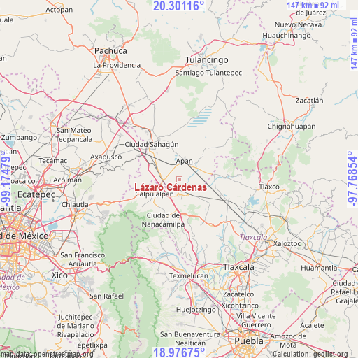
Lázaro Cárdenas GPS coordinates[2]
19° 38' 25.152" North, 98° 28' 17.976" West
| Map corner | latitude | longitude |
|---|---|---|
| Upper-left | 20.30116°, | -99.17479° |
| Center: | 19.64032°, | -98.47166° |
| Lower-right: | 18.97675°, | -97.76854° |
| Map W x H: | 147.3×147.3 km | = 91.5×91.5mi |
| max Lat: | 32.7° ⇑51.1% North |
| Lázaro Cárdenas: | 19.64032° |
| min Lat: | ⇓48.9% South 14.53588° |
| min Long | Lázaro Cárden | max Long |
| -117.105° | -98.47166° | -86.73105° |
| W 57.6%⇐ | ⇒42.4% E |
Elevation
Elevation of Lázaro Cárdenas is 2530 m = 8301 ft, and this is 1276.3 m = 4187 ft above average elevation for this country.
| Max E: |
3497 m = 11473 ft | 7% |
| Lázaro Cárdenas | 2530 m 8301 ft | |
| Avg. | 1253.7 m = 4113 ft | |
Min E: |
-1 m = -3 ft | 93% |
See also: Mexico elevation on elevation.city.
Geographical zone
Lázaro Cárdenas is located in North Torrid zone (between Equator and Tropic of Cancer). Distance of this Northern Tropic circle is 422.1 km =262.3 mi to North.| Distance of | km | miles | from Lázaro Cárdenas |
|---|---|---|---|
| North Pole | 7823.3 | 4861.2 | to North |
| Arctic Circle | 5217.4 | 3241.9 | to North |
| Tropic Cancer | 422.1 | 262.3 | to North |
| Equator | 2183.8 | 1356.9 | to South |


Nearby cities:
15 places around Lázaro Cárdenas: (largest is in red/bold)
• Acopinalco
10 km =6.2 mi,  320°
320°
• Almoloya
10.1 km =6.3 mi,  44°
44°
• Apan
8.2 km =5.1 mi,  15°
15°
• Benito Juárez
7.6 km =4.7 mi,  143°
143°
• Chimalpa y Tlalayote
5.1 km =3.2 mi,  303°
303°
• Emiliano Zapata
7.8 km =4.8 mi,  281°
281°
• Francisco Villa
6.1 km =3.8 mi,  170°
170°
• Jiquilpan
8.9 km =5.5 mi,  99°
99°
• Los Voladores
5.2 km =3.2 mi,  332°
332°
• NCP Álvaro Obregón
7.6 km =4.7 mi,  145°
145°
• Ocotepec
7.4 km =4.6 mi,  33°
33°
• Ocotepec de Morelos
10.3 km =6.4 mi,  69°
69°
• San Juan Ixtilmaco
3.7 km =2.3 mi, 38°
• Santa Bárbara
10.6 km =6.6 mi,  286°
286°
• Zotoluca
5.3 km =3.3 mi,  231°
231°
Sources, notices
• [Note1] Compared only with cities in Mexico existing in our database
• [Src1] Map data: © OpenStreetMap contributors (CC-BY-SA)
• [Src2] Other city data from geonames.org with taken over terms of usage.
• [Src3] Geographical zone / Annual Mean Temperature by Robert A. Rohde @ Wikipedia
