San Lorenzo Sóltepec geodata
San Lorenzo Sóltepec (Tlaxcala) is a populated place; located in Mexico in America/Mexico_City (GMT-6) time zone. With population of 1,019 people, there are 8541 cities with bigger population in this country. Compared to other cities in Mexico, 51.8% of cities are located further ↑North; 59.7% of cities are located further ←West and 93.1% of cities have lower elevation than San Lorenzo Sóltepec. Note1
Current local time in San Lorenzo Sóltepec:
05:28 AM, WednesdayDifference from your time zone: hours


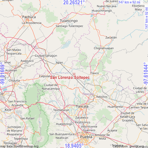
San Lorenzo Sóltepec GPS coordinates[2]
19° 36' 15.192" North, 98° 18' 48.816" West
| Map corner | latitude | longitude |
|---|---|---|
| Upper-left | 20.26521°, | -99.01669° |
| Center: | 19.60422°, | -98.31356° |
| Lower-right: | 18.9405°, | -97.61044° |
| Map W x H: | 147.3×147.3 km | = 91.5×91.5mi |
| max Lat: | 32.7° ⇑51.8% North |
| San Lorenzo Sóltepec: | 19.60422° |
| min Lat: | ⇓48.2% South 14.53588° |
| min Long | San Lorenzo Só | max Long |
| -117.105° | -98.31356° | -86.73105° |
| W 59.7%⇐ | ⇒40.3% E |
Elevation
Elevation of San Lorenzo Sóltepec is 2536 m = 8320 ft, and this is 1282.3 m = 4207 ft above average elevation for this country.
| Max E: |
3497 m = 11473 ft | 6.9% |
| San Lorenzo Sóltepec | 2536 m 8320 ft | |
| Avg. | 1253.7 m = 4113 ft | |
Min E: |
-1 m = -3 ft | 93.1% |
See also: Mexico elevation on elevation.city.
Geographical zone
San Lorenzo Sóltepec is located in North Torrid zone (between Equator and Tropic of Cancer). Distance of this Northern Tropic circle is 426.1 km =264.8 mi to North.| Distance of | km | miles | from San Lorenzo Sóltepec |
|---|---|---|---|
| North Pole | 7827.3 | 4863.7 | to North |
| Arctic Circle | 5221.4 | 3244.4 | to North |
| Tropic Cancer | 426.1 | 264.8 | to North |
| Equator | 2179.8 | 1354.5 | to South |


Nearby cities:
15 places around San Lorenzo Sóltepec: (largest is in red/bold)
• Benito Juárez
12.2 km =7.6 mi,  260°
260°
• Casa Blanca
10 km =6.2 mi,  49°
49°
• El Rosario
10.9 km =6.8 mi, 54°
• Guadalupe Cuauhtémoc
12.4 km =7.7 mi,  140°
140°
• Ignacio Zaragoza
7.8 km =4.8 mi,  239°
239°
• Jiquilpan
8.2 km =5.1 mi,  288°
288°
• La Magdalena Soltepec
2.6 km =1.6 mi,  179°
179°
• Lagunilla
5.4 km =3.4 mi, 49°
• Mariano Matamoros
6.9 km =4.3 mi,  32°
32°
• Ocotepec de Morelos
10.3 km =6.4 mi,  317°
317°
• San José Cuamantzingo
11.7 km =7.3 mi,  147°
147°
• San José Tepeyahualco
4.7 km =2.9 mi,  96°
96°
• Santiago Tetlapayac
9.8 km =6.1 mi,  348°
348°
• Unión Ejidal Tierra y Libertad
6.4 km =4 mi,  337°
337°
• Zumpango
10.7 km =6.6 mi,  118°
118°
Sources, notices
• [Note1] Compared only with cities in Mexico existing in our database
• [Src1] Map data: © OpenStreetMap contributors (CC-BY-SA)
• [Src2] Other city data from geonames.org with taken over terms of usage.
• [Src3] Geographical zone / Annual Mean Temperature by Robert A. Rohde @ Wikipedia
