Lagunilla geodata
Lagunilla (Tlaxcala) is a populated place; located in Mexico in America/Mexico_City (GMT-6) time zone. With population of 1,567 people, there are 5510 cities with bigger population in this country. Compared to other cities in Mexico, 51.2% of cities are located further ↑North; 60.2% of cities are located further ←West and 94.8% of cities have lower elevation than Lagunilla. Note1


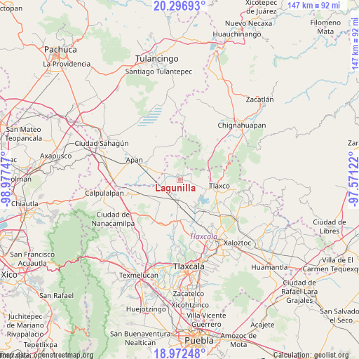
Lagunilla GPS coordinates[2]
19° 38' 9.852" North, 98° 16' 27.624" West
| Map corner | latitude | longitude |
|---|---|---|
| Upper-left | 20.29693°, | -98.97747° |
| Center: | 19.63607°, | -98.27434° |
| Lower-right: | 18.97248°, | -97.57122° |
| Map W x H: | 147.3×147.3 km | = 91.5×91.5mi |
| max Lat: | 32.7° ⇑51.2% North |
| Lagunilla: | 19.63607° |
| min Lat: | ⇓48.8% South 14.53588° |
| min Long | Lagunilla | max Long |
| -117.105° | -98.27434° | -86.73105° |
| W 60.2%⇐ | ⇒39.8% E |
Elevation
Elevation of Lagunilla is 2591 m = 8501 ft, and this is 1337.3 m = 4387 ft above average elevation for this country.
| Max E: |
3497 m = 11473 ft | 5.2% |
| Lagunilla | 2591 m 8501 ft | |
| Avg. | 1253.7 m = 4113 ft | |
Min E: |
-1 m = -3 ft | 94.8% |
See also: Mexico elevation on elevation.city.
Geographical zone
Lagunilla is located in North Torrid zone (between Equator and Tropic of Cancer). Distance of this Northern Tropic circle is 422.6 km =262.6 mi to North.| Distance of | km | miles | from Lagunilla |
|---|---|---|---|
| North Pole | 7823.7 | 4861.4 | to North |
| Arctic Circle | 5217.8 | 3242.2 | to North |
| Tropic Cancer | 422.6 | 262.6 | to North |
| Equator | 2183.3 | 1356.6 | to South |


Nearby cities:
15 places around Lagunilla: (largest is in red/bold)
• Acopinalco del Peñón
11.9 km =7.4 mi,  77°
77°
• Casa Blanca
4.6 km =2.9 mi,  49°
49°
• El Rosario
5.5 km =3.4 mi,  59°
59°
• Jiquilpan
11.9 km =7.4 mi,  265°
265°
• La Magdalena Soltepec
7.4 km =4.6 mi,  213°
213°
• Los Ranchos (Rinconada)
12.6 km =7.8 mi,  41°
41°
• Mariano Matamoros
2.3 km =1.4 mi,  350°
350°
• Ocotepec de Morelos
11.8 km =7.3 mi,  290°
290°
• Rancho Nuevo
12.5 km =7.8 mi,  357°
357°
• Rinconada
12.5 km =7.8 mi, 46°
• San José Tepeyahualco
4.1 km =2.5 mi,  172°
172°
• San Lorenzo Sóltepec
5.4 km =3.4 mi,  229°
229°
• Santiago Tetlapayac
8.6 km =5.3 mi,  314°
314°
• Unión Ejidal Tierra y Libertad
7 km =4.3 mi, 289°
• Zumpango
10.2 km =6.3 mi,  148°
148°
Sources, notices
• [Note1] Compared only with cities in Mexico existing in our database
• [Src1] Map data: © OpenStreetMap contributors (CC-BY-SA)
• [Src2] Other city data from geonames.org with taken over terms of usage.
• [Src3] Geographical zone / Annual Mean Temperature by Robert A. Rohde @ Wikipedia
