San Bartolomé Tenango geodata
San Bartolomé Tenango (Tlaxcala) is a populated place; located in Mexico in America/Mexico_City (GMT-6) time zone. With population of 1,807 people, there are 4820 cities with bigger population in this country. Compared to other cities in Mexico, 59.8% of cities are located further ↑North; 60% of cities are located further ←West and 86.4% of cities have lower elevation than San Bartolomé Tenango. Note1
Current local time in San Bartolomé Tenango:
06:56 AM, WednesdayDifference from your time zone: hours


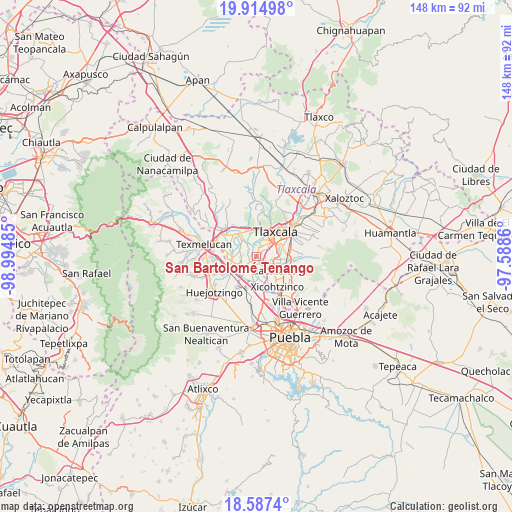
San Bartolomé Tenango GPS coordinates[2]
19° 15' 9.108" North, 98° 17' 30.192" West
| Map corner | latitude | longitude |
|---|---|---|
| Upper-left | 19.91498°, | -98.99485° |
| Center: | 19.25253°, | -98.29172° |
| Lower-right: | 18.5874°, | -97.5886° |
| Map W x H: | 147.6×147.6 km | = 91.7×91.7mi |
| max Lat: | 32.7° ⇑59.8% North |
| San Bartolomé Tenango: | 19.25253° |
| min Lat: | ⇓40.2% South 14.53588° |
| min Long | San Bartolomé | max Long |
| -117.105° | -98.29172° | -86.73105° |
| W 60%⇐ | ⇒40% E |
Elevation
Elevation of San Bartolomé Tenango is 2294 m = 7526 ft, and this is 1040.3 m = 3413 ft above average elevation for this country.
| Max E: |
3497 m = 11473 ft | 13.6% |
| San Bartolomé Tenango | 2294 m 7526 ft | |
| Avg. | 1253.7 m = 4113 ft | |
Min E: |
-1 m = -3 ft | 86.4% |
See also: Mexico elevation on elevation.city.
Geographical zone
San Bartolomé Tenango is located in North Torrid zone (between Equator and Tropic of Cancer). Distance of this Northern Tropic circle is 465.2 km =289.1 mi to North.| Distance of | km | miles | from San Bartolomé Tenango |
|---|---|---|---|
| North Pole | 7866.4 | 4888 | to North |
| Arctic Circle | 5260.5 | 3268.7 | to North |
| Tropic Cancer | 465.2 | 289.1 | to North |
| Equator | 2140.7 | 1330.2 | to South |


Nearby cities:
15 places around San Bartolomé Tenango: (largest is in red/bold)
• Guadalupe Victoria
5 km =3.1 mi,  243°
243°
• Jesús Tepactepec
3.5 km =2.2 mi,  222°
222°
• Natívitas
3.2 km =2 mi,  228°
228°
• San Damián Texoloc
2.9 km =1.8 mi,  12°
12°
• San Francisco Tenexyecac
3.8 km =2.4 mi,  318°
318°
• San Jerónimo Zacualpan
3.4 km =2.1 mi,  112°
112°
• San Juan Huactzinco
4.6 km =2.9 mi,  117°
117°
• San Lorenzo Axocomanitla
5.5 km =3.4 mi,  125°
125°
• San Miguel del Milagro
4.6 km =2.9 mi,  254°
254°
• Santa Ana Portales
5.9 km =3.7 mi,  190°
190°
• Santa Apolonia Teacalco
2.4 km =1.5 mi, 239°
• Santa Cruz Aquiahuac
1.8 km =1.1 mi,  145°
145°
• Santo Tomás la Concordia
3.9 km =2.4 mi, 228°
• Tepeyanco
6.1 km =3.8 mi,  97°
97°
• Tetlatlahuca
2.3 km =1.4 mi, 190°
Sources, notices
• [Note1] Compared only with cities in Mexico existing in our database
• [Src1] Map data: © OpenStreetMap contributors (CC-BY-SA)
• [Src2] Other city data from geonames.org with taken over terms of usage.
• [Src3] Geographical zone / Annual Mean Temperature by Robert A. Rohde @ Wikipedia
