San Juan Chancalaíto geodata
San Juan Chancalaíto (Chiapas) is a populated place; located in Mexico in America/Mexico_City (GMT-6) time zone. With population of 792 people, there are 11019 cities with bigger population in this country. Compared to other cities in Mexico, 84.8% of cities are located further ↑North; 95.9% of cities are located further ←West and 78.3% of cities have higher elevation than San Juan Chancalaíto. Note1
Current local time in San Juan Chancalaíto:
06:53 AM, WednesdayDifference from your time zone: hours


San Juan Chancalaíto GPS coordinates[2]
17° 20' 34.008" North, 91° 43' 33.996" West
| Map corner | latitude | longitude |
|---|---|---|
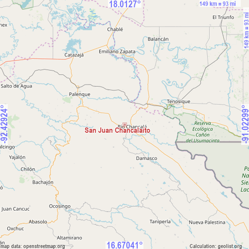
| Upper-left | 18.0127°, | -92.42924° |
| Center: | 17.34278°, | -91.72611° |
| Lower-right: | 16.67041°, | -91.02299° |
| Map W x H: | 149.2×149.3 km | = 92.7×92.8mi |
| max Lat: | 32.7° ⇑84.8% North |
| San Juan Chancalaíto: | 17.34278° |
| min Lat: | ⇓15.2% South 14.53588° |
| min Long | San Juan Chanca | max Long |
| -117.105° | -91.72611° | -86.73105° |
| W 95.9%⇐ | ⇒4.1% E |
Elevation
Elevation of San Juan Chancalaíto is 125 m = 410 ft, and this is 1128.7 m = 3703 ft below average elevation for this country.
| Max E: |
3497 m = 11473 ft | 78.3% |
| Avg. | 1253.7 m = 4113 ft | |
| San Juan Chancalaíto | 125 m = 410 ft | |
Min E: |
-1 m = -3 ft | 21.7% |
See also: Mexico elevation on elevation.city.
Geographical zone
San Juan Chancalaíto is located in North Torrid zone (between Equator and Tropic of Cancer). Distance of this Northern Tropic circle is 677.6 km =421 mi to North.| Distance of | km | miles | from San Juan Chancalaíto |
|---|---|---|---|
| North Pole | 8078.7 | 5019.9 | to North |
| Arctic Circle | 5472.8 | 3400.6 | to North |
| Tropic Cancer | 677.6 | 421 | to North |
| Equator | 1928.3 | 1198.2 | to South |


Nearby cities:
15 places around San Juan Chancalaíto: (largest is in red/bold)
• Agua Blanca Serranía
14.3 km =8.9 mi,  234°
234°
• Arimatea
16 km =9.9 mi,  269°
269°
• El Clavo
11.2 km =7 mi,  65°
65°
• El Desierto
10.8 km =6.7 mi,  20°
20°
• El Progreso
16.7 km =10.4 mi,  245°
245°
• Hermenegildo Galeana
7.7 km =4.8 mi, 245°
• La Cascada
8.9 km =5.5 mi,  290°
290°
• La Reforma de Ocampo
4.7 km =2.9 mi,  134°
134°
• Lázaro Cárdenas
18.6 km =11.6 mi,  83°
83°
• Nueva Galilea
13.7 km =8.5 mi,  258°
258°
• Nuevo San Joaquín
7.9 km =4.9 mi,  205°
205°
• Río Chancalá
4.5 km =2.8 mi,  101°
101°
• San Jerónimo Tulijá
14.9 km =9.3 mi, 207°
• San José Pathuitz
18.5 km =11.5 mi,  158°
158°
• San Martín Chamizal
15.3 km =9.5 mi,  124°
124°
Sources, notices
• [Note1] Compared only with cities in Mexico existing in our database
• [Src1] Map data: © OpenStreetMap contributors (CC-BY-SA)
• [Src2] Other city data from geonames.org with taken over terms of usage.
• [Src3] Geographical zone / Annual Mean Temperature by Robert A. Rohde @ Wikipedia
