El Progreso geodata
El Progreso (Chiapas) is a populated place; located in Mexico in America/Mexico_City (GMT-6) time zone. With population of 819 people, there are 10664 cities with bigger population in this country. Compared to other cities in Mexico, 85.5% of cities are located further ↑North; 95.7% of cities are located further ←West and 71.3% of cities have higher elevation than El Progreso. Note1


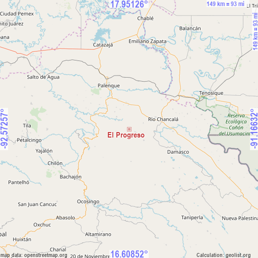
El Progreso GPS coordinates[2]
17° 16' 51.996" North, 91° 52' 9.984" West
| Map corner | latitude | longitude |
|---|---|---|
| Upper-left | 17.95126°, | -92.57257° |
| Center: | 17.28111°, | -91.86944° |
| Lower-right: | 16.60852°, | -91.16632° |
| Map W x H: | 149.3×149.3 km | = 92.8×92.8mi |
| max Lat: | 32.7° ⇑85.5% North |
| El Progreso: | 17.28111° |
| min Lat: | ⇓14.5% South 14.53588° |
| min Long | El Progreso | max Long |
| -117.105° | -91.86944° | -86.73105° |
| W 95.7%⇐ | ⇒4.3% E |
Elevation
Elevation of El Progreso is 355 m = 1165 ft, and this is 898.7 m = 2948 ft below average elevation for this country.
| Max E: |
3497 m = 11473 ft | 71.3% |
| Avg. | 1253.7 m = 4113 ft | |
| El Progreso | 355 m = 1165 ft | |
Min E: |
-1 m = -3 ft | 28.7% |
See also: Mexico elevation on elevation.city.
Geographical zone
El Progreso is located in North Torrid zone (between Equator and Tropic of Cancer). Distance of this Northern Tropic circle is 684.4 km =425.3 mi to North.| Distance of | km | miles | from El Progreso |
|---|---|---|---|
| North Pole | 8085.6 | 5024.2 | to North |
| Arctic Circle | 5479.7 | 3404.9 | to North |
| Tropic Cancer | 684.4 | 425.3 | to North |
| Equator | 1921.5 | 1194 | to South |


Nearby cities:
15 places around El Progreso: (largest is in red/bold)
• Agua Blanca Serranía
3.9 km =2.4 mi,  112°
112°
• Arimatea
6.7 km =4.2 mi,  353°
353°
• Egipto
11 km =6.8 mi,  258°
258°
• Estrella de Belén
15.1 km =9.4 mi,  321°
321°
• Hermenegildo Galeana
9 km =5.6 mi,  65°
65°
• La Aurora
14.6 km =9.1 mi,  329°
329°
• La Cascada
12.2 km =7.6 mi,  34°
34°
• Nazareth
13.2 km =8.2 mi, 320°
• Nueva Galilea
4.4 km =2.7 mi,  23°
23°
• Nuevo San Joaquín
11.8 km =7.3 mi,  91°
91°
• Profresor Roberto Barrios
7.8 km =4.8 mi,  309°
309°
• Puyipa
10.4 km =6.5 mi, 314°
• Río Jordán
7.8 km =4.8 mi,  240°
240°
• San Jerónimo Tulijá
10.6 km =6.6 mi,  127°
127°
• San Juan Tulija (San Juan)
11.4 km =7.1 mi,  246°
246°
Sources, notices
• [Note1] Compared only with cities in Mexico existing in our database
• [Src1] Map data: © OpenStreetMap contributors (CC-BY-SA)
• [Src2] Other city data from geonames.org with taken over terms of usage.
• [Src3] Geographical zone / Annual Mean Temperature by Robert A. Rohde @ Wikipedia
