Egipto geodata
Egipto (Chiapas) is a populated place; located in Mexico in America/Mexico_City (GMT-6) time zone. With population of 1,419 people, there are 6092 cities with bigger population in this country. Compared to other cities in Mexico, 85.8% of cities are located further ↑North; 95.4% of cities are located further ←West and 79.8% of cities have higher elevation than Egipto. Note1


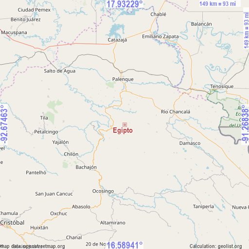
Egipto GPS coordinates[2]
17° 15' 43.452" North, 91° 58' 17.4" West
| Map corner | latitude | longitude |
|---|---|---|
| Upper-left | 17.93229°, | -92.67463° |
| Center: | 17.26207°, | -91.9715° |
| Lower-right: | 16.58941°, | -91.26838° |
| Map W x H: | 149.3×149.3 km | = 92.8×92.8mi |
| max Lat: | 32.7° ⇑85.8% North |
| Egipto: | 17.26207° |
| min Lat: | ⇓14.2% South 14.53588° |
| min Long | Egipto | max Long |
| -117.105° | -91.9715° | -86.73105° |
| W 95.4%⇐ | ⇒4.6% E |
Elevation
Elevation of Egipto is 98 m = 322 ft, and this is 1155.7 m = 3792 ft below average elevation for this country.
| Max E: |
3497 m = 11473 ft | 79.8% |
| Avg. | 1253.7 m = 4113 ft | |
| Egipto | 98 m = 322 ft | |
Min E: |
-1 m = -3 ft | 20.2% |
See also: Mexico elevation on elevation.city.
Geographical zone
Egipto is located in North Torrid zone (between Equator and Tropic of Cancer). Distance of this Northern Tropic circle is 686.6 km =426.6 mi to North.| Distance of | km | miles | from Egipto |
|---|---|---|---|
| North Pole | 8087.7 | 5025.5 | to North |
| Arctic Circle | 5481.8 | 3406.2 | to North |
| Tropic Cancer | 686.6 | 426.6 | to North |
| Equator | 1919.4 | 1192.7 | to South |


Nearby cities:
15 places around Egipto: (largest is in red/bold)
• Adolfo Ruiz Cortínes
13.9 km =8.6 mi,  355°
355°
• Agua Blanca Serranía
14.4 km =8.9 mi,  87°
87°
• Arimatea
13.4 km =8.3 mi,  48°
48°
• El Progreso
11 km =6.8 mi,  78°
78°
• Estrella de Belén
14 km =8.7 mi,  5°
5°
• Francisco I. Madero
14.4 km =8.9 mi,  322°
322°
• Nazareth
12.4 km =7.7 mi, 11°
• Nueva Galilea
14 km =8.7 mi,  63°
63°
• Profresor Roberto Barrios
8.6 km =5.3 mi,  34°
34°
• Puyipa
10.1 km =6.3 mi,  20°
20°
• Río Jordán
4.5 km =2.8 mi,  113°
113°
• Río Tulija
8.8 km =5.5 mi,  295°
295°
• San Juan Tulija (San Juan)
2.4 km =1.5 mi,  171°
171°
• San Miguel
11.9 km =7.4 mi,  341°
341°
• Vicente Guerrero
10 km =6.2 mi, 302°
Sources, notices
• [Note1] Compared only with cities in Mexico existing in our database
• [Src1] Map data: © OpenStreetMap contributors (CC-BY-SA)
• [Src2] Other city data from geonames.org with taken over terms of usage.
• [Src3] Geographical zone / Annual Mean Temperature by Robert A. Rohde @ Wikipedia
