Guadalupe Paxiljá geodata
Guadalupe Paxiljá (Chiapas) is a populated place; located in Mexico in America/Mexico_City (GMT-6) time zone. With population of 649 people, there are 13347 cities with bigger population in this country. Compared to other cities in Mexico, 87.5% of cities are located further ↑North; 95.1% of cities are located further ←West and 67.5% of cities have higher elevation than Guadalupe Paxiljá. Note1


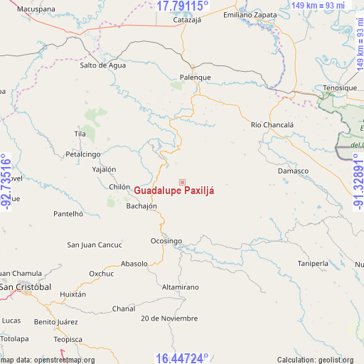
Guadalupe Paxiljá GPS coordinates[2]
17° 7' 13.476" North, 92° 1' 55.308" West
| Map corner | latitude | longitude |
|---|---|---|
| Upper-left | 17.79115°, | -92.73516° |
| Center: | 17.12041°, | -92.03203° |
| Lower-right: | 16.44724°, | -91.32891° |
| Map W x H: | 149.4×149.4 km | = 92.8×92.8mi |
| max Lat: | 32.7° ⇑87.5% North |
| Guadalupe Paxiljá: | 17.12041° |
| min Lat: | ⇓12.5% South 14.53588° |
| min Long | Guadalupe Paxil | max Long |
| -117.105° | -92.03203° | -86.73105° |
| W 95.1%⇐ | ⇒4.9% E |
Elevation
Elevation of Guadalupe Paxiljá is 551 m = 1808 ft, and this is 702.7 m = 2305 ft below average elevation for this country.
| Max E: |
3497 m = 11473 ft | 67.5% |
| Avg. | 1253.7 m = 4113 ft | |
| Guadalupe Paxiljá | 551 m = 1808 ft | |
Min E: |
-1 m = -3 ft | 32.5% |
See also: Mexico elevation on elevation.city.
Geographical zone
Guadalupe Paxiljá is located in North Torrid zone (between Equator and Tropic of Cancer). Distance of this Northern Tropic circle is 702.3 km =436.4 mi to North.| Distance of | km | miles | from Guadalupe Paxiljá |
|---|---|---|---|
| North Pole | 8103.5 | 5035.3 | to North |
| Arctic Circle | 5497.6 | 3416 | to North |
| Tropic Cancer | 702.3 | 436.4 | to North |
| Equator | 1903.6 | 1182.8 | to South |


Nearby cities:
15 places around Guadalupe Paxiljá: (largest is in red/bold)
• Centro Chich
14 km =8.7 mi,  293°
293°
• Chabán
14.3 km =8.9 mi,  318°
318°
• Chiquinival
16.3 km =10.1 mi,  152°
152°
• Corostic
13.5 km =8.4 mi,  272°
272°
• Egipto
17 km =10.6 mi,  22°
22°
• El Carmen
11.9 km =7.4 mi,  182°
182°
• El Mango
5.5 km =3.4 mi,  327°
327°
• Jet-Já
12.5 km =7.8 mi,  117°
117°
• Jol Hic'Batil
2.8 km =1.7 mi,  55°
55°
• Patatehel
15.5 km =9.6 mi, 291°
• Sacún Cubwitz
9.7 km =6 mi,  84°
84°
• San Juan Tulija (San Juan)
15 km =9.3 mi,  26°
26°
• Santiago Pojcol
15.3 km =9.5 mi,  159°
159°
• Tzobojitle Jotoaquil
13 km =8.1 mi,  195°
195°
• Xaxajatic
13.6 km =8.5 mi,  283°
283°
Sources, notices
• [Note1] Compared only with cities in Mexico existing in our database
• [Src1] Map data: © OpenStreetMap contributors (CC-BY-SA)
• [Src2] Other city data from geonames.org with taken over terms of usage.
• [Src3] Geographical zone / Annual Mean Temperature by Robert A. Rohde @ Wikipedia
