Chivaltic Nuevo geodata
Chivaltic Nuevo (Chiapas) is a populated place; located in Mexico in America/Mexico_City (GMT-6) time zone. With population of 885 people, there are 9853 cities with bigger population in this country. Compared to other cities in Mexico, 84% of cities are located further ↑North; 94.9% of cities are located further ←West and 65.8% of cities have higher elevation than Chivaltic Nuevo. Note1


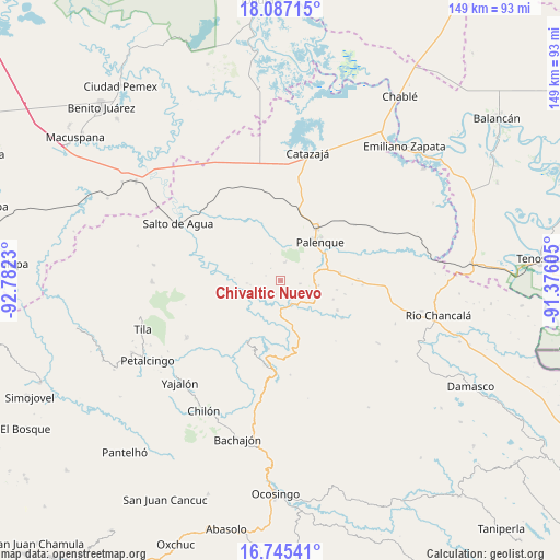
Chivaltic Nuevo GPS coordinates[2]
17° 25' 3.036" North, 92° 4' 45.012" West
| Map corner | latitude | longitude |
|---|---|---|
| Upper-left | 18.08715°, | -92.7823° |
| Center: | 17.41751°, | -92.07917° |
| Lower-right: | 16.74541°, | -91.37605° |
| Map W x H: | 149.2×149.2 km | = 92.7×92.7mi |
| max Lat: | 32.7° ⇑84% North |
| Chivaltic Nuevo: | 17.41751° |
| min Lat: | ⇓16% South 14.53588° |
| min Long | Chivaltic Nuevo | max Long |
| -117.105° | -92.07917° | -86.73105° |
| W 94.9%⇐ | ⇒5.1% E |
Elevation
Elevation of Chivaltic Nuevo is 648 m = 2126 ft, and this is 605.7 m = 1987 ft below average elevation for this country.
| Max E: |
3497 m = 11473 ft | 65.8% |
| Avg. | 1253.7 m = 4113 ft | |
| Chivaltic Nuevo | 648 m = 2126 ft | |
Min E: |
-1 m = -3 ft | 34.2% |
See also: Mexico elevation on elevation.city.
Geographical zone
Chivaltic Nuevo is located in North Torrid zone (between Equator and Tropic of Cancer). Distance of this Northern Tropic circle is 669.3 km =415.9 mi to North.| Distance of | km | miles | from Chivaltic Nuevo |
|---|---|---|---|
| North Pole | 8070.4 | 5014.7 | to North |
| Arctic Circle | 5464.5 | 3395.5 | to North |
| Tropic Cancer | 669.3 | 415.9 | to North |
| Equator | 1936.6 | 1203.3 | to South |


Nearby cities:
15 places around Chivaltic Nuevo: (largest is in red/bold)
• Adolfo Ruiz Cortínes
10.8 km =6.7 mi,  108°
108°
• Arroyo Palenque
3.9 km =2.4 mi,  223°
223°
• Babilonia
11.7 km =7.3 mi,  52°
52°
• Belisario Domínguez
10.2 km =6.3 mi,  97°
97°
• El Bascán (Lucha Bascán)
3.9 km =2.4 mi,  200°
200°
• El Naranjo
5 km =3.1 mi,  12°
12°
• Francisco I. Madero
6.4 km =4 mi,  154°
154°
• Ignacio Zaragoza
5.1 km =3.2 mi, 98°
• Jerusalén
5.8 km =3.6 mi,  160°
160°
• San Miguel
9.7 km =6 mi,  128°
128°
• Santa María
7.3 km =4.5 mi,  178°
178°
• Suclumpa
9 km =5.6 mi,  265°
265°
• Tiemopa
12.5 km =7.8 mi, 273°
• Tioquipa el Bascán
7.7 km =4.8 mi,  241°
241°
• Vicente Guerrero
12.3 km =7.6 mi,  166°
166°
Sources, notices
• [Note1] Compared only with cities in Mexico existing in our database
• [Src1] Map data: © OpenStreetMap contributors (CC-BY-SA)
• [Src2] Other city data from geonames.org with taken over terms of usage.
• [Src3] Geographical zone / Annual Mean Temperature by Robert A. Rohde @ Wikipedia
