Tioquipa el Bascán geodata
Tioquipa el Bascán (Chiapas) is a populated place; located in Mexico in America/Mexico_City (GMT-6) time zone. With population of 658 people, there are 13187 cities with bigger population in this country. Compared to other cities in Mexico, 84.4% of cities are located further ↑North; 94.6% of cities are located further ←West and 82.3% of cities have higher elevation than Tioquipa el Bascán. Note1


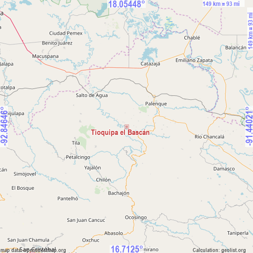
Tioquipa el Bascán GPS coordinates[2]
17° 23' 4.992" North, 92° 8' 35.988" West
| Map corner | latitude | longitude |
|---|---|---|
| Upper-left | 18.05448°, | -92.84646° |
| Center: | 17.38472°, | -92.14333° |
| Lower-right: | 16.7125°, | -91.44021° |
| Map W x H: | 149.2×149.2 km | = 92.7×92.7mi |
| max Lat: | 32.7° ⇑84.4% North |
| Tioquipa el Bascán: | 17.38472° |
| min Lat: | ⇓15.6% South 14.53588° |
| min Long | Tioquipa el Bas | max Long |
| -117.105° | -92.14333° | -86.73105° |
| W 94.6%⇐ | ⇒5.4% E |
Elevation
Elevation of Tioquipa el Bascán is 67 m = 220 ft, and this is 1186.7 m = 3893 ft below average elevation for this country.
| Max E: |
3497 m = 11473 ft | 82.3% |
| Avg. | 1253.7 m = 4113 ft | |
| Tioquipa el Bascán | 67 m = 220 ft | |
Min E: |
-1 m = -3 ft | 17.7% |
See also: Mexico elevation on elevation.city.
Geographical zone
Tioquipa el Bascán is located in North Torrid zone (between Equator and Tropic of Cancer). Distance of this Northern Tropic circle is 672.9 km =418.1 mi to North.| Distance of | km | miles | from Tioquipa el Bascán |
|---|---|---|---|
| North Pole | 8074.1 | 5017 | to North |
| Arctic Circle | 5468.2 | 3397.8 | to North |
| Tropic Cancer | 672.9 | 418.1 | to North |
| Equator | 1933 | 1201.1 | to South |


Nearby cities:
15 places around Tioquipa el Bascán: (largest is in red/bold)
• Arroyo Palenque
4.2 km =2.6 mi,  79°
79°
• Cacahuatal
11.2 km =7 mi,  231°
231°
• Chivaltic Nuevo
7.7 km =4.8 mi,  61°
61°
• Cuctiepa
9.3 km =5.8 mi,  202°
202°
• El Bascán (Lucha Bascán)
5.5 km =3.4 mi,  89°
89°
• El Naranjo
11.6 km =7.2 mi,  42°
42°
• Francisco I. Madero
9.8 km =6.1 mi,  102°
102°
• Ignacio Zaragoza
12.2 km =7.6 mi, 76°
• Jerusalén
8.9 km =5.5 mi, 101°
• San Pedro
7.6 km =4.7 mi,  279°
279°
• Santa María
7.9 km =4.9 mi,  117°
117°
• Suclumpa
3.7 km =2.3 mi,  323°
323°
• Tiemopa
7.2 km =4.5 mi,  308°
308°
• Tientiul Grande 2da. Sección (Agua Potable)
11.6 km =7.2 mi,  269°
269°
• Venustiano Carranza
9.7 km =6 mi, 199°
Sources, notices
• [Note1] Compared only with cities in Mexico existing in our database
• [Src1] Map data: © OpenStreetMap contributors (CC-BY-SA)
• [Src2] Other city data from geonames.org with taken over terms of usage.
• [Src3] Geographical zone / Annual Mean Temperature by Robert A. Rohde @ Wikipedia
