Pomposo Castellanos geodata
Pomposo Castellanos (Chiapas) is a populated place; located in Mexico in America/Mexico_City (GMT-6) time zone. With population of 1,489 people, there are 5797 cities with bigger population in this country. Compared to other cities in Mexico, 93.7% of cities are located further ↑North; 85.9% of cities are located further ←West and 66.3% of cities have higher elevation than Pomposo Castellanos. Note1


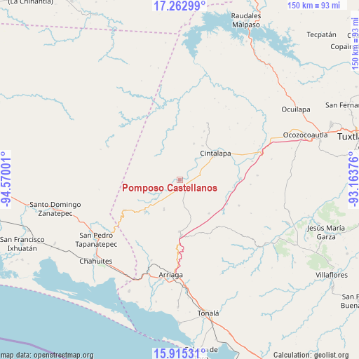
Pomposo Castellanos GPS coordinates[2]
16° 35' 25.188" North, 93° 52' 0.768" West
| Map corner | latitude | longitude |
|---|---|---|
| Upper-left | 17.26299°, | -94.57001° |
| Center: | 16.59033°, | -93.86688° |
| Lower-right: | 15.91531°, | -93.16376° |
| Map W x H: | 149.8×149.9 km | = 93.1×93.1mi |
| max Lat: | 32.7° ⇑93.7% North |
| Pomposo Castellanos: | 16.59033° |
| min Lat: | ⇓6.3% South 14.53588° |
| min Long | Pomposo Castell | max Long |
| -117.105° | -93.86688° | -86.73105° |
| W 85.9%⇐ | ⇒14.1% E |
Elevation
Elevation of Pomposo Castellanos is 620 m = 2034 ft, and this is 633.7 m = 2079 ft below average elevation for this country.
| Max E: |
3497 m = 11473 ft | 66.3% |
| Avg. | 1253.7 m = 4113 ft | |
| Pomposo Castellanos | 620 m = 2034 ft | |
Min E: |
-1 m = -3 ft | 33.7% |
See also: Mexico elevation on elevation.city.
Geographical zone
Pomposo Castellanos is located in North Torrid zone (between Equator and Tropic of Cancer). Distance of this Northern Tropic circle is 761.2 km =473 mi to North.| Distance of | km | miles | from Pomposo Castellanos |
|---|---|---|---|
| North Pole | 8162.4 | 5071.9 | to North |
| Arctic Circle | 5556.5 | 3452.6 | to North |
| Tropic Cancer | 761.2 | 473 | to North |
| Equator | 1844.7 | 1146.2 | to South |


Nearby cities:
15 places around Pomposo Castellanos: (largest is in red/bold)
• Abelardo L. Rodríguez
11.2 km =7 mi,  38°
38°
• Baja California
19.1 km =11.9 mi,  156°
156°
• Cereso 14 (El Amate)
6.8 km =4.2 mi,  85°
85°
• Chiapas Nuevo
15.6 km =9.7 mi, 164°
• Cintalapa de Figueroa
19 km =11.8 mi,  56°
56°
• Cuauhtémoc
16.7 km =10.4 mi,  105°
105°
• El Triunfo
18.6 km =11.6 mi,  138°
138°
• Emiliano Zapata
16.3 km =10.1 mi,  21°
21°
• Jacinto Tirado
17 km =10.6 mi,  34°
34°
• José María Pino Suárez
16.6 km =10.3 mi,  124°
124°
• Lázaro Cárdenas
8.2 km =5.1 mi,  79°
79°
• Mérida
5.9 km =3.7 mi, 115°
• Rosendo Salazar
19.8 km =12.3 mi,  226°
226°
• Tehuacán
10.2 km =6.3 mi,  272°
272°
• Villamorelos
13.9 km =8.6 mi,  207°
207°
Sources, notices
• [Note1] Compared only with cities in Mexico existing in our database
• [Src1] Map data: © OpenStreetMap contributors (CC-BY-SA)
• [Src2] Other city data from geonames.org with taken over terms of usage.
• [Src3] Geographical zone / Annual Mean Temperature by Robert A. Rohde @ Wikipedia
