Mérida geodata
Mérida (Chiapas) is a populated place; located in Mexico in America/Mexico_City (GMT-6) time zone. With population of 1,412 people, there are 6125 cities with bigger population in this country. Compared to other cities in Mexico, 93.9% of cities are located further ↑North; 86% of cities are located further ←West and 65.4% of cities have higher elevation than Mérida. Note1


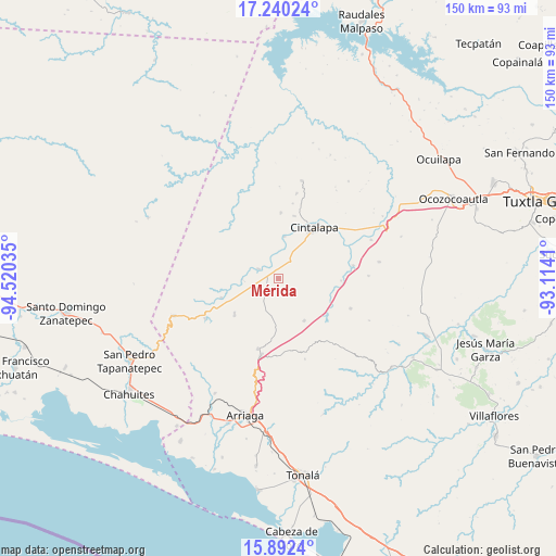
Mérida GPS coordinates[2]
16° 34' 3" North, 93° 49' 1.992" West
| Map corner | latitude | longitude |
|---|---|---|
| Upper-left | 17.24024°, | -94.52035° |
| Center: | 16.5675°, | -93.81722° |
| Lower-right: | 15.8924°, | -93.1141° |
| Map W x H: | 149.9×149.9 km | = 93.1×93.1mi |
| max Lat: | 32.7° ⇑93.9% North |
| Mérida: | 16.5675° |
| min Lat: | ⇓6.1% South 14.53588° |
| min Long | Mérida | max Long |
| -117.105° | -93.81722° | -86.73105° |
| W 86%⇐ | ⇒14% E |
Elevation
Elevation of Mérida is 664 m = 2178 ft, and this is 589.7 m = 1935 ft below average elevation for this country.
| Max E: |
3497 m = 11473 ft | 65.4% |
| Avg. | 1253.7 m = 4113 ft | |
| Mérida | 664 m = 2178 ft | |
Min E: |
-1 m = -3 ft | 34.6% |
See also: Mexico elevation on elevation.city.
Geographical zone
Mérida is located in North Torrid zone (between Equator and Tropic of Cancer). Distance of this Northern Tropic circle is 763.8 km =474.6 mi to North.| Distance of | km | miles | from Mérida |
|---|---|---|---|
| North Pole | 8164.9 | 5073.4 | to North |
| Arctic Circle | 5559 | 3454.2 | to North |
| Tropic Cancer | 763.8 | 474.6 | to North |
| Equator | 1842.1 | 1144.6 | to South |


Nearby cities:
15 places around Mérida: (largest is in red/bold)
• Abelardo L. Rodríguez
11.4 km =7.1 mi,  8°
8°
• Baja California
15.1 km =9.4 mi,  171°
171°
• Cereso 14 (El Amate)
3.4 km =2.1 mi,  26°
26°
• Chiapas Nuevo
12.5 km =7.8 mi,  184°
184°
• Cintalapa de Figueroa
16.7 km =10.4 mi,  39°
39°
• Cuauhtémoc
11 km =6.8 mi,  100°
100°
• El Triunfo
13.4 km =8.3 mi,  148°
148°
• Emiliano Zapata
17.7 km =11 mi,  2°
2°
• Jacinto Tirado
17.1 km =10.6 mi, 14°
• José María Pino Suárez
10.8 km =6.7 mi,  129°
129°
• Lázaro Cárdenas
4.9 km =3 mi, 34°
• Miguel Hidalgo
17 km =10.6 mi,  92°
92°
• Pomposo Castellanos
5.9 km =3.7 mi,  295°
295°
• Tehuacán
15.8 km =9.8 mi,  280°
280°
• Villamorelos
15.3 km =9.5 mi,  230°
230°
Sources, notices
• [Note1] Compared only with cities in Mexico existing in our database
• [Src1] Map data: © OpenStreetMap contributors (CC-BY-SA)
• [Src2] Other city data from geonames.org with taken over terms of usage.
• [Src3] Geographical zone / Annual Mean Temperature by Robert A. Rohde @ Wikipedia
