Chiapas Nuevo geodata
Chiapas Nuevo (Chiapas) is a populated place; located in Mexico in America/Mexico_City (GMT-6) time zone. With population of 579 people, there are 14804 cities with bigger population in this country. Compared to other cities in Mexico, 94.7% of cities are located further ↑North; 86% of cities are located further ←West and 65.6% of cities have higher elevation than Chiapas Nuevo. Note1


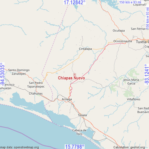
Chiapas Nuevo GPS coordinates[2]
16° 27' 19.008" North, 93° 49' 37.992" West
| Map corner | latitude | longitude |
|---|---|---|
| Upper-left | 17.12842°, | -94.53035° |
| Center: | 16.45528°, | -93.82722° |
| Lower-right: | 15.7798°, | -93.1241° |
| Map W x H: | 150×150 km | = 93.2×93.2mi |
| max Lat: | 32.7° ⇑94.7% North |
| Chiapas Nuevo: | 16.45528° |
| min Lat: | ⇓5.3% South 14.53588° |
| min Long | Chiapas Nuevo | max Long |
| -117.105° | -93.82722° | -86.73105° |
| W 86%⇐ | ⇒14% E |
Elevation
Elevation of Chiapas Nuevo is 656 m = 2152 ft, and this is 597.7 m = 1961 ft below average elevation for this country.
| Max E: |
3497 m = 11473 ft | 65.6% |
| Avg. | 1253.7 m = 4113 ft | |
| Chiapas Nuevo | 656 m = 2152 ft | |
Min E: |
-1 m = -3 ft | 34.4% |
See also: Mexico elevation on elevation.city.
Geographical zone
Chiapas Nuevo is located in North Torrid zone (between Equator and Tropic of Cancer). Distance of this Northern Tropic circle is 776.3 km =482.4 mi to North.| Distance of | km | miles | from Chiapas Nuevo |
|---|---|---|---|
| North Pole | 8177.4 | 5081.2 | to North |
| Arctic Circle | 5571.5 | 3462 | to North |
| Tropic Cancer | 776.3 | 482.4 | to North |
| Equator | 1829.7 | 1136.9 | to South |


Nearby cities:
15 places around Chiapas Nuevo: (largest is in red/bold)
• Baja California
4.2 km =2.6 mi,  125°
125°
• Cereso 14 (El Amate)
15.7 km =9.8 mi,  9°
9°
• Cuauhtémoc
15.9 km =9.9 mi,  48°
48°
• El Triunfo
8.1 km =5 mi,  83°
83°
• José María Pino Suárez
10.9 km =6.8 mi,  59°
59°
• Julián Grajales
12.4 km =7.7 mi,  103°
103°
• Lázaro Cárdenas
17 km =10.6 mi, 12°
• Mérida
12.5 km =7.8 mi,  4°
4°
• Nueva Palestina
21.1 km =13.1 mi, 78°
• Pomposo Castellanos
15.6 km =9.7 mi,  344°
344°
• Rosendo Salazar
18.6 km =11.6 mi,  274°
274°
• Tierra y Libertad
9.2 km =5.7 mi,  202°
202°
• Tiltepec
8.2 km =5.1 mi,  213°
213°
• Unión Agrarista
15.9 km =9.9 mi, 81°
• Villamorelos
11.1 km =6.9 mi,  284°
284°
Sources, notices
• [Note1] Compared only with cities in Mexico existing in our database
• [Src1] Map data: © OpenStreetMap contributors (CC-BY-SA)
• [Src2] Other city data from geonames.org with taken over terms of usage.
• [Src3] Geographical zone / Annual Mean Temperature by Robert A. Rohde @ Wikipedia
