Venustiano Carranza geodata
Venustiano Carranza (Chiapas) is a populated place; located in Mexico in America/Mexico_City (GMT-6) time zone. With population of 1,301 people, there are 6669 cities with bigger population in this country. Compared to other cities in Mexico, 90.3% of cities are located further ↑North; 88.6% of cities are located further ←West and 52.3% of cities have higher elevation than Venustiano Carranza. Note1


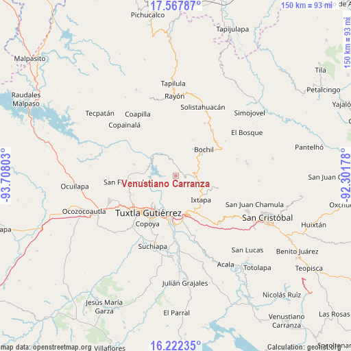
Venustiano Carranza GPS coordinates[2]
16° 53' 46.716" North, 93° 0' 17.64" West
| Map corner | latitude | longitude |
|---|---|---|
| Upper-left | 17.56787°, | -93.70803° |
| Center: | 16.89631°, | -93.0049° |
| Lower-right: | 16.22235°, | -92.30178° |
| Map W x H: | 149.6×149.6 km | = 93×93mi |
| max Lat: | 32.7° ⇑90.3% North |
| Venustiano Carranza: | 16.89631° |
| min Lat: | ⇓9.7% South 14.53588° |
| min Long | Venustiano Carr | max Long |
| -117.105° | -93.0049° | -86.73105° |
| W 88.6%⇐ | ⇒11.4% E |
Elevation
Elevation of Venustiano Carranza is 1323 m = 4341 ft, and this is 69.3 m = 227 ft above average elevation for this country.
| Max E: |
3497 m = 11473 ft | 52.3% |
| Venustiano Carranza | 1323 m 4341 ft | |
| Avg. | 1253.7 m = 4113 ft | |
Min E: |
-1 m = -3 ft | 47.7% |
See also: Mexico elevation on elevation.city.
Geographical zone
Venustiano Carranza is located in North Torrid zone (between Equator and Tropic of Cancer). Distance of this Northern Tropic circle is 727.2 km =451.9 mi to North.| Distance of | km | miles | from Venustiano Carranza |
|---|---|---|---|
| North Pole | 8128.4 | 5050.8 | to North |
| Arctic Circle | 5522.5 | 3431.5 | to North |
| Tropic Cancer | 727.2 | 451.9 | to North |
| Equator | 1878.7 | 1167.4 | to South |


Nearby cities:
15 places around Venustiano Carranza: (largest is in red/bold)
• Concepción
10.6 km =6.6 mi,  156°
156°
• El Copal
11.5 km =7.1 mi,  46°
46°
• El Horizonte
5.1 km =3.2 mi,  109°
109°
• El Palmar (San Gabriel)
5.8 km =3.6 mi,  192°
192°
• El Zapotillo
8.7 km =5.4 mi,  139°
139°
• Francisco Sarabia
5.6 km =3.5 mi,  351°
351°
• Libertad Campesina
3.6 km =2.2 mi,  237°
237°
• Miguel Hidalgo
7.1 km =4.4 mi,  148°
148°
• Modelo (El Zapotal)
10.4 km =6.5 mi,  127°
127°
• Osumacinta
10.1 km =6.3 mi,  295°
295°
• San Antonio Zaragoza
4 km =2.5 mi,  309°
309°
• San Vicente
10.9 km =6.8 mi, 52°
• Soyaló
8.6 km =5.3 mi,  93°
93°
• Triunfo Agrarista
8.4 km =5.2 mi, 236°
• Venustiano Carranza
10.8 km =6.7 mi, 47°
Sources, notices
• [Note1] Compared only with cities in Mexico existing in our database
• [Src1] Map data: © OpenStreetMap contributors (CC-BY-SA)
• [Src2] Other city data from geonames.org with taken over terms of usage.
• [Src3] Geographical zone / Annual Mean Temperature by Robert A. Rohde @ Wikipedia
