El Copal geodata
El Copal (Chiapas) is a populated place; located in Mexico in America/Mexico_City (GMT-6) time zone. With population of 1,133 people, there are 7654 cities with bigger population in this country. Compared to other cities in Mexico, 89.3% of cities are located further ↑North; 89.1% of cities are located further ←West and 50.8% of cities have higher elevation than El Copal. Note1


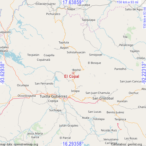
El Copal GPS coordinates[2]
16° 58' 2.244" North, 92° 55' 34.5" West
| Map corner | latitude | longitude |
|---|---|---|
| Upper-left | 17.63859°, | -93.62938° |
| Center: | 16.96729°, | -92.92625° |
| Lower-right: | 16.29358°, | -92.22313° |
| Map W x H: | 149.6×149.6 km | = 93×93mi |
| max Lat: | 32.7° ⇑89.3% North |
| El Copal: | 16.96729° |
| min Lat: | ⇓10.7% South 14.53588° |
| min Long | El Copal | max Long |
| -117.105° | -92.92625° | -86.73105° |
| W 89.1%⇐ | ⇒10.9% E |
Elevation
Elevation of El Copal is 1392 m = 4567 ft, and this is 138.3 m = 454 ft above average elevation for this country.
| Max E: |
3497 m = 11473 ft | 50.8% |
| El Copal | 1392 m 4567 ft | |
| Avg. | 1253.7 m = 4113 ft | |
Min E: |
-1 m = -3 ft | 49.2% |
See also: Mexico elevation on elevation.city.
Geographical zone
El Copal is located in North Torrid zone (between Equator and Tropic of Cancer). Distance of this Northern Tropic circle is 719.3 km =447 mi to North.| Distance of | km | miles | from El Copal |
|---|---|---|---|
| North Pole | 8120.5 | 5045.8 | to North |
| Arctic Circle | 5514.6 | 3426.6 | to North |
| Tropic Cancer | 719.3 | 447 | to North |
| Equator | 1886.6 | 1172.3 | to South |


Nearby cities:
15 places around El Copal: (largest is in red/bold)
• Ajilhó
2.2 km =1.4 mi,  325°
325°
• Bochil
4.8 km =3 mi,  48°
48°
• Buenavista
9.3 km =5.8 mi,  114°
114°
• Chuchiltón
10.2 km =6.3 mi,  95°
95°
• Chuchiltón Anexo Potobtic Dos
8.3 km =5.2 mi,  85°
85°
• Francisco Sarabia
9.5 km =5.9 mi,  255°
255°
• Llano Grande
9.3 km =5.8 mi,  321°
321°
• Monte Grande
7.5 km =4.7 mi,  115°
115°
• San Pedro el Achiote (San Pedro Mártir)
3.7 km =2.3 mi,  351°
351°
• San Vicente
1.3 km =0.8 mi,  167°
167°
• Soyaló
8.5 km =5.3 mi,  178°
178°
• Tierra Colorada
5.4 km =3.4 mi,  12°
12°
• Venustiano Carranza
0.8 km =0.5 mi,  210°
210°
• Victórico R. Grajales (Iglesia Vieja)
8.8 km =5.5 mi,  150°
150°
• Yerbabuena Isbontick
7.5 km =4.7 mi, 120°
Sources, notices
• [Note1] Compared only with cities in Mexico existing in our database
• [Src1] Map data: © OpenStreetMap contributors (CC-BY-SA)
• [Src2] Other city data from geonames.org with taken over terms of usage.
• [Src3] Geographical zone / Annual Mean Temperature by Robert A. Rohde @ Wikipedia
