Venustiano Carranza geodata
Venustiano Carranza (Chiapas) is a populated place; located in Mexico in America/Mexico_City (GMT-6) time zone. With population of 747 people, there are 11723 cities with bigger population in this country. Compared to other cities in Mexico, 89.4% of cities are located further ↑North; 89% of cities are located further ←West and 50.3% of cities have lower elevation than Venustiano Carranza. Note1


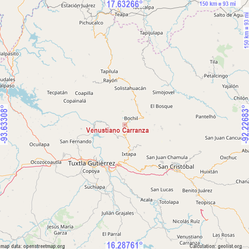
Venustiano Carranza GPS coordinates[2]
16° 57' 40.824" North, 92° 55' 47.82" West
| Map corner | latitude | longitude |
|---|---|---|
| Upper-left | 17.63266°, | -93.63308° |
| Center: | 16.96134°, | -92.92995° |
| Lower-right: | 16.28761°, | -92.22683° |
| Map W x H: | 149.6×149.6 km | = 93×93mi |
| max Lat: | 32.7° ⇑89.4% North |
| Venustiano Carranza: | 16.96134° |
| min Lat: | ⇓10.6% South 14.53588° |
| min Long | Venustiano Carr | max Long |
| -117.105° | -92.92995° | -86.73105° |
| W 89%⇐ | ⇒11% E |
Elevation
Elevation of Venustiano Carranza is 1447 m = 4747 ft, and this is 193.3 m = 634 ft above average elevation for this country.
| Max E: |
3497 m = 11473 ft | 49.7% |
| Venustiano Carranza | 1447 m 4747 ft | |
| Avg. | 1253.7 m = 4113 ft | |
Min E: |
-1 m = -3 ft | 50.3% |
See also: Mexico elevation on elevation.city.
Geographical zone
Venustiano Carranza is located in North Torrid zone (between Equator and Tropic of Cancer). Distance of this Northern Tropic circle is 720 km =447.4 mi to North.| Distance of | km | miles | from Venustiano Carranza |
|---|---|---|---|
| North Pole | 8121.1 | 5046.2 | to North |
| Arctic Circle | 5515.2 | 3427 | to North |
| Tropic Cancer | 720 | 447.4 | to North |
| Equator | 1885.9 | 1171.8 | to South |


Nearby cities:
15 places around Venustiano Carranza: (largest is in red/bold)
• Ajilhó
2.6 km =1.6 mi,  340°
340°
• Bochil
5.6 km =3.5 mi,  45°
45°
• Buenavista
9.5 km =5.9 mi,  110°
110°
• Chuchiltón Anexo Potobtic Dos
8.7 km =5.4 mi,  81°
81°
• El Copal
0.8 km =0.5 mi,  30°
30°
• El Horizonte
9.5 km =5.9 mi,  199°
199°
• Francisco Sarabia
9 km =5.6 mi,  258°
258°
• Llano Grande
9.6 km =6 mi,  325°
325°
• Monte Grande
7.6 km =4.7 mi, 109°
• San Pedro el Achiote (San Pedro Mártir)
4.3 km =2.7 mi,  357°
357°
• San Vicente
0.9 km =0.6 mi,  132°
132°
• Soyaló
7.8 km =4.8 mi,  175°
175°
• Tierra Colorada
6.2 km =3.9 mi,  15°
15°
• Victórico R. Grajales (Iglesia Vieja)
8.4 km =5.2 mi,  146°
146°
• Yerbabuena Isbontick
7.5 km =4.7 mi, 114°
Sources, notices
• [Note1] Compared only with cities in Mexico existing in our database
• [Src1] Map data: © OpenStreetMap contributors (CC-BY-SA)
• [Src2] Other city data from geonames.org with taken over terms of usage.
• [Src3] Geographical zone / Annual Mean Temperature by Robert A. Rohde @ Wikipedia
