Nichén geodata
Nichén (Chiapas) is a populated place; located in Mexico in America/Mexico_City (GMT-6) time zone. With population of 602 people, there are 14290 cities with bigger population in this country. Compared to other cities in Mexico, 91.7% of cities are located further ↑North; 90.6% of cities are located further ←West and 86.8% of cities have lower elevation than Nichén. Note1


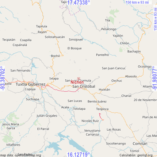
Nichén GPS coordinates[2]
16° 48' 5.328" North, 92° 41' 2.004" West
| Map corner | latitude | longitude |
|---|---|---|
| Upper-left | 17.47338°, | -93.38702° |
| Center: | 16.80148°, | -92.68389° |
| Lower-right: | 16.12719°, | -91.98077° |
| Map W x H: | 149.7×149.7 km | = 93×93mi |
| max Lat: | 32.7° ⇑91.7% North |
| Nichén: | 16.80148° |
| min Lat: | ⇓8.3% South 14.53588° |
| min Long | Nichén | max Long |
| -117.105° | -92.68389° | -86.73105° |
| W 90.6%⇐ | ⇒9.4% E |
Elevation
Elevation of Nichén is 2303 m = 7556 ft, and this is 1049.3 m = 3443 ft above average elevation for this country.
| Max E: |
3497 m = 11473 ft | 13.2% |
| Nichén | 2303 m 7556 ft | |
| Avg. | 1253.7 m = 4113 ft | |
Min E: |
-1 m = -3 ft | 86.8% |
See also: Mexico elevation on elevation.city.
Geographical zone
Nichén is located in North Torrid zone (between Equator and Tropic of Cancer). Distance of this Northern Tropic circle is 737.8 km =458.4 mi to North.| Distance of | km | miles | from Nichén |
|---|---|---|---|
| North Pole | 8138.9 | 5057.3 | to North |
| Arctic Circle | 5533 | 3438 | to North |
| Tropic Cancer | 737.8 | 458.4 | to North |
| Equator | 1868.1 | 1160.8 | to South |


Nearby cities:
15 places around Nichén: (largest is in red/bold)
• Arvenza Uno
4.6 km =2.9 mi,  238°
238°
• Bautista Chico
3 km =1.9 mi,  266°
266°
• Bechijtic
3.1 km =1.9 mi,  202°
202°
• Chamula
2 km =1.2 mi, 197°
• Chicviltenal
3.3 km =2.1 mi,  38°
38°
• Cruz Quemada
2.8 km =1.7 mi,  336°
336°
• Cuchulumtic
3.5 km =2.2 mi,  218°
218°
• Ichintón
4.4 km =2.7 mi,  177°
177°
• La Ventana
4.1 km =2.5 mi, 197°
• Laguna Petej
2.2 km =1.4 mi,  127°
127°
• Milpoleta
4.1 km =2.5 mi,  142°
142°
• Pilalchén
4.3 km =2.7 mi,  358°
358°
• Seteltón
4.7 km =2.9 mi,  285°
285°
• Tzajaltetic
2.2 km =1.4 mi,  306°
306°
• Yutniotic
4.7 km =2.9 mi,  59°
59°
Sources, notices
• [Note1] Compared only with cities in Mexico existing in our database
• [Src1] Map data: © OpenStreetMap contributors (CC-BY-SA)
• [Src2] Other city data from geonames.org with taken over terms of usage.
• [Src3] Geographical zone / Annual Mean Temperature by Robert A. Rohde @ Wikipedia
