Laguna Petej geodata
Laguna Petej (Chiapas) is a populated place; located in Mexico in America/Mexico_City (GMT-6) time zone. With population of 752 people, there are 11651 cities with bigger population in this country. Compared to other cities in Mexico, 91.9% of cities are located further ↑North; 90.7% of cities are located further ←West and 87.7% of cities have lower elevation than Laguna Petej. Note1


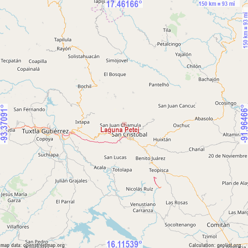
Laguna Petej GPS coordinates[2]
16° 47' 22.992" North, 92° 40' 4.008" West
| Map corner | latitude | longitude |
|---|---|---|
| Upper-left | 17.46166°, | -93.37091° |
| Center: | 16.78972°, | -92.66778° |
| Lower-right: | 16.11539°, | -91.96466° |
| Map W x H: | 149.7×149.7 km | = 93×93mi |
| max Lat: | 32.7° ⇑91.9% North |
| Laguna Petej: | 16.78972° |
| min Lat: | ⇓8.1% South 14.53588° |
| min Long | Laguna Petej | max Long |
| -117.105° | -92.66778° | -86.73105° |
| W 90.7%⇐ | ⇒9.3% E |
Elevation
Elevation of Laguna Petej is 2331 m = 7648 ft, and this is 1077.3 m = 3534 ft above average elevation for this country.
| Max E: |
3497 m = 11473 ft | 12.3% |
| Laguna Petej | 2331 m 7648 ft | |
| Avg. | 1253.7 m = 4113 ft | |
Min E: |
-1 m = -3 ft | 87.7% |
See also: Mexico elevation on elevation.city.
Geographical zone
Laguna Petej is located in North Torrid zone (between Equator and Tropic of Cancer). Distance of this Northern Tropic circle is 739.1 km =459.3 mi to North.| Distance of | km | miles | from Laguna Petej |
|---|---|---|---|
| North Pole | 8140.2 | 5058.1 | to North |
| Arctic Circle | 5534.3 | 3438.9 | to North |
| Tropic Cancer | 739.1 | 459.3 | to North |
| Equator | 1866.8 | 1160 | to South |


Nearby cities:
15 places around Laguna Petej: (largest is in red/bold)
• Bautista Chico
4.8 km =3 mi,  283°
283°
• Bechijtic
3.3 km =2.1 mi,  241°
241°
• Chamula
2.4 km =1.5 mi,  255°
255°
• Chicviltenal
3.9 km =2.4 mi,  5°
5°
• Cruz Quemada
4.8 km =3 mi,  323°
323°
• Cuchulumtic
4.1 km =2.5 mi,  250°
250°
• Ichintón
3.4 km =2.1 mi,  206°
206°
• La Selva Natividad
4.2 km =2.6 mi, 212°
• La Ventana
4 km =2.5 mi,  227°
227°
• Milpoleta
2.1 km =1.3 mi,  158°
158°
• Nichén
2.2 km =1.4 mi,  307°
307°
• Saclamantón
3.5 km =2.2 mi,  92°
92°
• San Antonio del Monte
3.6 km =2.2 mi,  154°
154°
• Tzajaltetic
4.4 km =2.7 mi, 306°
• Yutniotic
4.3 km =2.7 mi,  32°
32°
Sources, notices
• [Note1] Compared only with cities in Mexico existing in our database
• [Src1] Map data: © OpenStreetMap contributors (CC-BY-SA)
• [Src2] Other city data from geonames.org with taken over terms of usage.
• [Src3] Geographical zone / Annual Mean Temperature by Robert A. Rohde @ Wikipedia
