Arvenza Uno geodata
Arvenza Uno (Chiapas) is a populated place; located in Mexico in America/Mexico_City (GMT-6) time zone. With population of 1,107 people, there are 7851 cities with bigger population in this country. Compared to other cities in Mexico, 92% of cities are located further ↑North; 90.4% of cities are located further ←West and 87.2% of cities have lower elevation than Arvenza Uno. Note1


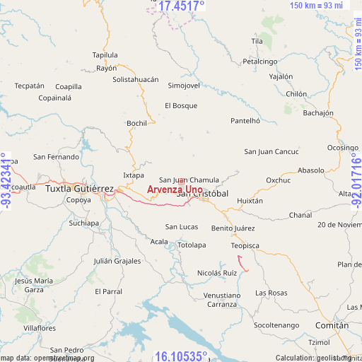
Arvenza Uno GPS coordinates[2]
16° 46' 46.992" North, 92° 43' 13.008" West
| Map corner | latitude | longitude |
|---|---|---|
| Upper-left | 17.4517°, | -93.42341° |
| Center: | 16.77972°, | -92.72028° |
| Lower-right: | 16.10535°, | -92.01716° |
| Map W x H: | 149.7×149.7 km | = 93×93mi |
| max Lat: | 32.7° ⇑92% North |
| Arvenza Uno: | 16.77972° |
| min Lat: | ⇓8% South 14.53588° |
| min Long | Arvenza Uno | max Long |
| -117.105° | -92.72028° | -86.73105° |
| W 90.4%⇐ | ⇒9.6% E |
Elevation
Elevation of Arvenza Uno is 2314 m = 7592 ft, and this is 1060.3 m = 3479 ft above average elevation for this country.
| Max E: |
3497 m = 11473 ft | 12.8% |
| Arvenza Uno | 2314 m 7592 ft | |
| Avg. | 1253.7 m = 4113 ft | |
Min E: |
-1 m = -3 ft | 87.2% |
See also: Mexico elevation on elevation.city.
Geographical zone
Arvenza Uno is located in North Torrid zone (between Equator and Tropic of Cancer). Distance of this Northern Tropic circle is 740.2 km =459.9 mi to North.| Distance of | km | miles | from Arvenza Uno |
|---|---|---|---|
| North Pole | 8141.3 | 5058.8 | to North |
| Arctic Circle | 5535.4 | 3439.5 | to North |
| Tropic Cancer | 740.2 | 459.9 | to North |
| Equator | 1865.7 | 1159.3 | to South |


Nearby cities:
15 places around Arvenza Uno: (largest is in red/bold)
• Bahosil
0.8 km =0.5 mi,  265°
265°
• Bautista Chico
2.4 km =1.5 mi,  21°
21°
• Bautista Grande
2.2 km =1.4 mi,  336°
336°
• Bechijtic
2.7 km =1.7 mi,  100°
100°
• Catishtic
1.9 km =1.2 mi, 271°
• Chamula
3.3 km =2.1 mi,  81°
81°
• Cuchulumtic
1.7 km =1.1 mi, 99°
• La Selva Natividad
4.1 km =2.5 mi,  126°
126°
• La Ventana
3.1 km =1.9 mi,  120°
120°
• Patosil
3.8 km =2.4 mi,  216°
216°
• Santa Ana
3.5 km =2.2 mi,  329°
329°
• Seteltón
3.7 km =2.3 mi,  350°
350°
• Tzajaltetic
4.3 km =2.7 mi,  29°
29°
• Ukumtic
1.7 km =1.1 mi,  318°
318°
• Zinacantán
2.2 km =1.4 mi,  186°
186°
Sources, notices
• [Note1] Compared only with cities in Mexico existing in our database
• [Src1] Map data: © OpenStreetMap contributors (CC-BY-SA)
• [Src2] Other city data from geonames.org with taken over terms of usage.
• [Src3] Geographical zone / Annual Mean Temperature by Robert A. Rohde @ Wikipedia
