Alamul geodata
Alamul (Chiapas) is a populated place; located in Mexico in America/Mexico_City (GMT-6) time zone. With population of 657 people, there are 13209 cities with bigger population in this country. Compared to other cities in Mexico, 90.5% of cities are located further ↑North; 91.6% of cities are located further ←West and 68.3% of cities have lower elevation than Alamul. Note1


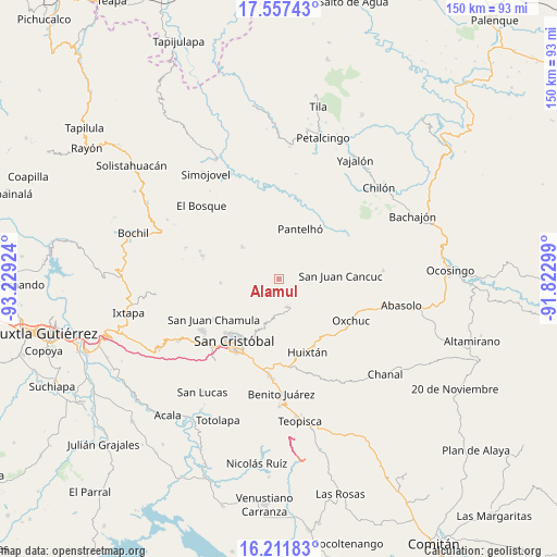
Alamul GPS coordinates[2]
16° 53' 8.988" North, 92° 31' 33.996" West
| Map corner | latitude | longitude |
|---|---|---|
| Upper-left | 17.55743°, | -93.22924° |
| Center: | 16.88583°, | -92.52611° |
| Lower-right: | 16.21183°, | -91.82299° |
| Map W x H: | 149.6×149.6 km | = 93×93mi |
| max Lat: | 32.7° ⇑90.5% North |
| Alamul: | 16.88583° |
| min Lat: | ⇓9.5% South 14.53588° |
| min Long | Alamul | max Long |
| -117.105° | -92.52611° | -86.73105° |
| W 91.6%⇐ | ⇒8.4% E |
Elevation
Elevation of Alamul is 1895 m = 6217 ft, and this is 641.3 m = 2104 ft above average elevation for this country.
| Max E: |
3497 m = 11473 ft | 31.7% |
| Alamul | 1895 m 6217 ft | |
| Avg. | 1253.7 m = 4113 ft | |
Min E: |
-1 m = -3 ft | 68.3% |
See also: Mexico elevation on elevation.city.
Geographical zone
Alamul is located in North Torrid zone (between Equator and Tropic of Cancer). Distance of this Northern Tropic circle is 728.4 km =452.6 mi to North.| Distance of | km | miles | from Alamul |
|---|---|---|---|
| North Pole | 8129.5 | 5051.4 | to North |
| Arctic Circle | 5523.6 | 3432.2 | to North |
| Tropic Cancer | 728.4 | 452.6 | to North |
| Equator | 1877.5 | 1166.6 | to South |


Nearby cities:
15 places around Alamul: (largest is in red/bold)
• Cancuc
5.7 km =3.5 mi,  53°
53°
• Chacoma
3.8 km =2.4 mi,  106°
106°
• Chalam
2.6 km =1.6 mi,  274°
274°
• Chana
5.2 km =3.2 mi,  91°
91°
• Chimhucum
0.7 km =0.4 mi,  309°
309°
• La Libertad
4.8 km =3 mi,  295°
295°
• Oxinam
3.5 km =2.2 mi,  224°
224°
• Pactetón
5.3 km =3.3 mi,  67°
67°
• Puebla
4.1 km =2.5 mi,  35°
35°
• Pulumsibac
1 km =0.6 mi,  243°
243°
• Sivactel
1.7 km =1.1 mi, 66°
• Suyalhó
5.4 km =3.4 mi,  263°
263°
• Titaltetic
3.5 km =2.2 mi,  245°
245°
• Tojtic
3 km =1.9 mi,  275°
275°
• Tzoeptic
4.5 km =2.8 mi, 265°
Sources, notices
• [Note1] Compared only with cities in Mexico existing in our database
• [Src1] Map data: © OpenStreetMap contributors (CC-BY-SA)
• [Src2] Other city data from geonames.org with taken over terms of usage.
• [Src3] Geographical zone / Annual Mean Temperature by Robert A. Rohde @ Wikipedia
