La Floresta geodata
La Floresta (Chiapas) is a populated place; located in Mexico in America/Mexico_City (GMT-6) time zone. With population of 1,743 people, there are 4980 cities with bigger population in this country. Compared to other cities in Mexico, 94.3% of cities are located further ↑North; 93.3% of cities are located further ←West and 81.6% of cities have lower elevation than La Floresta. Note1


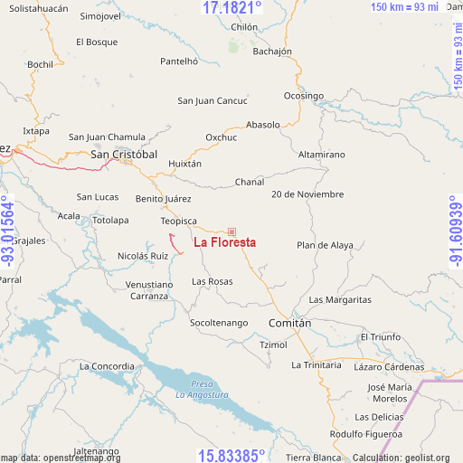
La Floresta GPS coordinates[2]
16° 30' 32.94" North, 92° 18' 45.036" West
| Map corner | latitude | longitude |
|---|---|---|
| Upper-left | 17.1821°, | -93.01564° |
| Center: | 16.50915°, | -92.31251° |
| Lower-right: | 15.83385°, | -91.60939° |
| Map W x H: | 149.9×149.9 km | = 93.1×93.1mi |
| max Lat: | 32.7° ⇑94.3% North |
| La Floresta: | 16.50915° |
| min Lat: | ⇓5.7% South 14.53588° |
| min Long | La Floresta | max Long |
| -117.105° | -92.31251° | -86.73105° |
| W 93.3%⇐ | ⇒6.7% E |
Elevation
Elevation of La Floresta is 2177 m = 7142 ft, and this is 923.3 m = 3029 ft above average elevation for this country.
| Max E: |
3497 m = 11473 ft | 18.4% |
| La Floresta | 2177 m 7142 ft | |
| Avg. | 1253.7 m = 4113 ft | |
Min E: |
-1 m = -3 ft | 81.6% |
See also: Mexico elevation on elevation.city.
Geographical zone
La Floresta is located in North Torrid zone (between Equator and Tropic of Cancer). Distance of this Northern Tropic circle is 770.3 km =478.6 mi to North.| Distance of | km | miles | from La Floresta |
|---|---|---|---|
| North Pole | 8171.4 | 5077.5 | to North |
| Arctic Circle | 5565.5 | 3458.2 | to North |
| Tropic Cancer | 770.3 | 478.6 | to North |
| Equator | 1835.6 | 1140.6 | to South |


Nearby cities:
15 places around La Floresta: (largest is in red/bold)
• Abelardo L. Rodríguez
16.3 km =10.1 mi,  151°
151°
• Aguacatenango
11 km =6.8 mi,  249°
249°
• Amatenango del Valle
13.2 km =8.2 mi,  278°
278°
• Carmen Yalchuch
16 km =9.9 mi,  340°
340°
• Chanal
17.5 km =10.9 mi,  19°
19°
• Dos Lagunas (San Isidro)
16.2 km =10.1 mi,  308°
308°
• El Madronal
13.2 km =8.2 mi,  272°
272°
• El Puerto
15.6 km =9.7 mi,  233°
233°
• Guadalupe Palmira
6.9 km =4.3 mi,  172°
172°
• Las Rosas
17.1 km =10.6 mi,  201°
201°
• San Pedro Pedernal
17.2 km =10.7 mi,  356°
356°
• Santa Rosalía
7.9 km =4.9 mi,  118°
118°
• Siberia
12.3 km =7.6 mi,  9°
9°
• Teopisca
17.6 km =10.9 mi, 281°
• Zaragoza la Montaña
15.4 km =9.6 mi,  131°
131°
Sources, notices
• [Note1] Compared only with cities in Mexico existing in our database
• [Src1] Map data: © OpenStreetMap contributors (CC-BY-SA)
• [Src2] Other city data from geonames.org with taken over terms of usage.
• [Src3] Geographical zone / Annual Mean Temperature by Robert A. Rohde @ Wikipedia
