Abelardo L. Rodríguez geodata
Abelardo L. Rodríguez (Chiapas) is a populated place; located in Mexico in America/Mexico_City (GMT-6) time zone. With population of 855 people, there are 10232 cities with bigger population in this country. Compared to other cities in Mexico, 95.1% of cities are located further ↑North; 93.8% of cities are located further ←West and 69.9% of cities have lower elevation than Abelardo L. Rodríguez. Note1


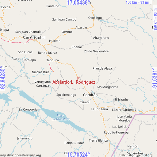
Abelardo L. Rodríguez GPS coordinates[2]
16° 22' 51.528" North, 92° 14' 21.192" West
| Map corner | latitude | longitude |
|---|---|---|
| Upper-left | 17.05438°, | -92.94235° |
| Center: | 16.38098°, | -92.23922° |
| Lower-right: | 15.70524°, | -91.5361° |
| Map W x H: | 150×150 km | = 93.2×93.2mi |
| max Lat: | 32.7° ⇑95.1% North |
| Abelardo L. Rodríguez: | 16.38098° |
| min Lat: | ⇓4.9% South 14.53588° |
| min Long | Abelardo L. Rod | max Long |
| -117.105° | -92.23922° | -86.73105° |
| W 93.8%⇐ | ⇒6.2% E |
Elevation
Elevation of Abelardo L. Rodríguez is 1921 m = 6302 ft, and this is 667.3 m = 2189 ft above average elevation for this country.
| Max E: |
3497 m = 11473 ft | 30.1% |
| Abelardo L. Rodríguez | 1921 m 6302 ft | |
| Avg. | 1253.7 m = 4113 ft | |
Min E: |
-1 m = -3 ft | 69.9% |
See also: Mexico elevation on elevation.city.
Geographical zone
Abelardo L. Rodríguez is located in North Torrid zone (between Equator and Tropic of Cancer). Distance of this Northern Tropic circle is 784.5 km =487.5 mi to North.| Distance of | km | miles | from Abelardo L. Rodríguez |
|---|---|---|---|
| North Pole | 8185.7 | 5086.4 | to North |
| Arctic Circle | 5579.8 | 3467.1 | to North |
| Tropic Cancer | 784.5 | 487.5 | to North |
| Equator | 1821.4 | 1131.8 | to South |


Nearby cities:
15 places around Abelardo L. Rodríguez: (largest is in red/bold)
• Chacaljocóm
10.9 km =6.8 mi,  146°
146°
• Efraín A. Gutiérrez
5.9 km =3.7 mi,  133°
133°
• Guadalupe Palmira
10.2 km =6.3 mi,  316°
316°
• Juznajab la Laguna
14.7 km =9.1 mi,  89°
89°
• La Floresta
16.3 km =10.1 mi,  331°
331°
• Las Rosas
14.1 km =8.8 mi,  263°
263°
• Los Riegos
14.9 km =9.3 mi,  124°
124°
• Quija
15.5 km =9.6 mi,  140°
140°
• San Francisco el Rincón
15.8 km =9.8 mi, 134°
• San Rafael Jocom
15.2 km =9.4 mi, 127°
• Santa Rosalía
10.5 km =6.5 mi,  355°
355°
• Santo Domingo de las Granadas
15.4 km =9.6 mi, 122°
• Tzinil
16.3 km =10.1 mi,  212°
212°
• Yaltzi Tres Lagunas
9.3 km =5.8 mi,  193°
193°
• Zaragoza la Montaña
5.4 km =3.4 mi,  42°
42°
Sources, notices
• [Note1] Compared only with cities in Mexico existing in our database
• [Src1] Map data: © OpenStreetMap contributors (CC-BY-SA)
• [Src2] Other city data from geonames.org with taken over terms of usage.
• [Src3] Geographical zone / Annual Mean Temperature by Robert A. Rohde @ Wikipedia
