Las Rosas geodata
Las Rosas (Chiapas) is a seat of a second-order administrative division; located in Mexico in America/Mexico_City (GMT-6) time zone. With population of 18,817 people, there are 521 cities with bigger population in this country. Compared to other cities in Mexico, 95.2% of cities are located further ↑North; 93% of cities are located further ←West and 52.6% of cities have higher elevation than Las Rosas. Note1


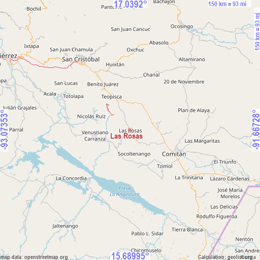
Las Rosas GPS coordinates[2]
16° 21' 56.664" North, 92° 22' 13.44" West
| Map corner | latitude | longitude |
|---|---|---|
| Upper-left | 17.0392°, | -93.07353° |
| Center: | 16.36574°, | -92.3704° |
| Lower-right: | 15.68995°, | -91.66728° |
| Map W x H: | 150×150 km | = 93.2×93.2mi |
| max Lat: | 32.7° ⇑95.2% North |
| Las Rosas: | 16.36574° |
| min Lat: | ⇓4.8% South 14.53588° |
| min Long | Las Rosas | max Long |
| -117.105° | -92.3704° | -86.73105° |
| W 93%⇐ | ⇒7% E |
Elevation
Elevation of Las Rosas is 1312 m = 4304 ft, and this is 58.3 m = 191 ft above average elevation for this country.
| Max E: |
3497 m = 11473 ft | 52.6% |
| Las Rosas | 1312 m 4304 ft | |
| Avg. | 1253.7 m = 4113 ft | |
Min E: |
-1 m = -3 ft | 47.4% |
See also: Mexico elevation on elevation.city.
Geographical zone
Las Rosas is located in North Torrid zone (between Equator and Tropic of Cancer). Distance of this Northern Tropic circle is 786.2 km =488.5 mi to North.| Distance of | km | miles | from Las Rosas |
|---|---|---|---|
| North Pole | 8187.4 | 5087.4 | to North |
| Arctic Circle | 5581.5 | 3468.2 | to North |
| Tropic Cancer | 786.2 | 488.5 | to North |
| Equator | 1819.7 | 1130.7 | to South |


Nearby cities:
15 places around Las Rosas: (largest is in red/bold)
• Abelardo L. Rodríguez
14.1 km =8.8 mi,  83°
83°
• Aguacatenango
12.7 km =7.9 mi,  341°
341°
• Corral Hierba
6 km =3.7 mi,  249°
249°
• El Puerto
9.3 km =5.8 mi,  316°
316°
• Grandeza del Río Blanco
14.1 km =8.8 mi,  278°
278°
• Guadalupe Palmira
11.5 km =7.1 mi,  37°
37°
• Ixtapilla
6.4 km =4 mi,  267°
267°
• La Floresta
17.1 km =10.6 mi,  21°
21°
• La Gloria (La Tranca)
12.6 km =7.8 mi,  236°
236°
• San Francisco Pujiltic
13.1 km =8.1 mi,  222°
222°
• Socoltenango
13.6 km =8.5 mi,  170°
170°
• Soyatitán
9.8 km =6.1 mi, 215°
• Tzinil
13.1 km =8.1 mi,  156°
156°
• Yaltzi Tres Lagunas
14 km =8.7 mi,  121°
121°
• Zacualpa
7 km =4.3 mi,  188°
188°
Sources, notices
• [Note1] Compared only with cities in Mexico existing in our database
• [Src1] Map data: © OpenStreetMap contributors (CC-BY-SA)
• [Src2] Other city data from geonames.org with taken over terms of usage.
• [Src3] Geographical zone / Annual Mean Temperature by Robert A. Rohde @ Wikipedia
