San Francisco geodata
San Francisco (Chiapas) is a populated place; located in Mexico in America/Mexico_City (GMT-6) time zone. With population of 603 people, there are 14266 cities with bigger population in this country. Compared to other cities in Mexico, 93.6% of cities are located further ↑North; 95.9% of cities are located further ←West and 62.9% of cities have higher elevation than San Francisco. Note1


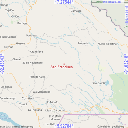
San Francisco GPS coordinates[2]
16° 36' 10.152" North, 91° 44' 7.08" West
| Map corner | latitude | longitude |
|---|---|---|
| Upper-left | 17.27544°, | -92.43843° |
| Center: | 16.60282°, | -91.7353° |
| Lower-right: | 15.92784°, | -91.03218° |
| Map W x H: | 149.8×149.8 km | = 93.1×93.1mi |
| max Lat: | 32.7° ⇑93.6% North |
| San Francisco: | 16.60282° |
| min Lat: | ⇓6.4% South 14.53588° |
| min Long | San Francisco | max Long |
| -117.105° | -91.7353° | -86.73105° |
| W 95.9%⇐ | ⇒4.1% E |
Elevation
Elevation of San Francisco is 829 m = 2720 ft, and this is 424.7 m = 1393 ft below average elevation for this country.
| Max E: |
3497 m = 11473 ft | 62.9% |
| Avg. | 1253.7 m = 4113 ft | |
| San Francisco | 829 m = 2720 ft | |
Min E: |
-1 m = -3 ft | 37.1% |
See also: Mexico elevation on elevation.city.
Geographical zone
San Francisco is located in North Torrid zone (between Equator and Tropic of Cancer). Distance of this Northern Tropic circle is 759.9 km =472.2 mi to North.| Distance of | km | miles | from San Francisco |
|---|---|---|---|
| North Pole | 8161 | 5071 | to North |
| Arctic Circle | 5555.1 | 3451.8 | to North |
| Tropic Cancer | 759.9 | 472.2 | to North |
| Equator | 1846.1 | 1147.1 | to South |


Nearby cities:
15 places around San Francisco: (largest is in red/bold)
• Belisario Domínguez
4.9 km =3 mi,  350°
350°
• Carmen Rusia
11.3 km =7 mi,  254°
254°
• El Prado Pacayal
11.1 km =6.9 mi,  40°
40°
• El Triunfo
8.3 km =5.2 mi,  343°
343°
• Las Tazas
21.4 km =13.3 mi, 36°
• Luis Espinoza
12.2 km =7.6 mi,  97°
97°
• Patihuitz
15.1 km =9.4 mi,  359°
359°
• Río Corozal
19.8 km =12.3 mi,  128°
128°
• San Juan Bautista
18.7 km =11.6 mi,  146°
146°
• San Juan Rómulo Calzada
13.6 km =8.5 mi,  76°
76°
• San Juan del Pozo
19.8 km =12.3 mi,  172°
172°
• San Luis Potosí
9.5 km =5.9 mi,  89°
89°
• San Marcos
3.3 km =2.1 mi,  30°
30°
• San Miguel
24.8 km =15.4 mi,  330°
330°
• Santo Tomás
23.7 km =14.7 mi,  55°
55°
Sources, notices
• [Note1] Compared only with cities in Mexico existing in our database
• [Src1] Map data: © OpenStreetMap contributors (CC-BY-SA)
• [Src2] Other city data from geonames.org with taken over terms of usage.
• [Src3] Geographical zone / Annual Mean Temperature by Robert A. Rohde @ Wikipedia
