La Patria geodata
La Patria (Chiapas) is a populated place; located in Mexico in America/Mexico_City (GMT-6) time zone. With population of 1,616 people, there are 5361 cities with bigger population in this country. Compared to other cities in Mexico, 96.1% of cities are located further ↑North; 95.6% of cities are located further ←West and 51.4% of cities have lower elevation than La Patria. Note1


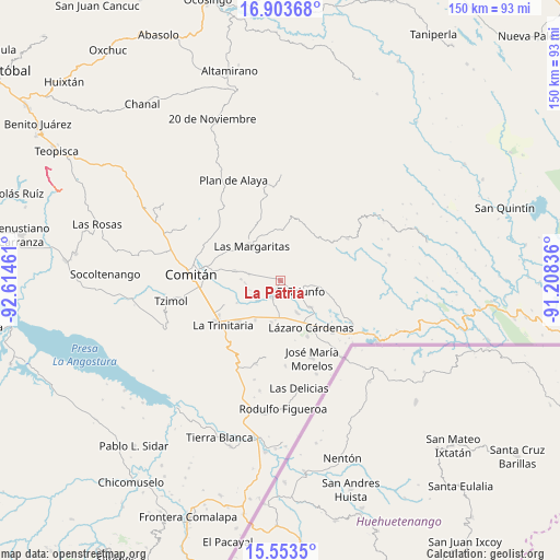
La Patria GPS coordinates[2]
16° 13' 47.1" North, 91° 54' 41.328" West
| Map corner | latitude | longitude |
|---|---|---|
| Upper-left | 16.90368°, | -92.61461° |
| Center: | 16.22975°, | -91.91148° |
| Lower-right: | 15.5535°, | -91.20836° |
| Map W x H: | 150.1×150.1 km | = 93.3×93.3mi |
| max Lat: | 32.7° ⇑96.1% North |
| La Patria: | 16.22975° |
| min Lat: | ⇓3.9% South 14.53588° |
| min Long | La Patria | max Long |
| -117.105° | -91.91148° | -86.73105° |
| W 95.6%⇐ | ⇒4.4% E |
Elevation
Elevation of La Patria is 1501 m = 4925 ft, and this is 247.3 m = 811 ft above average elevation for this country.
| Max E: |
3497 m = 11473 ft | 48.6% |
| La Patria | 1501 m 4925 ft | |
| Avg. | 1253.7 m = 4113 ft | |
Min E: |
-1 m = -3 ft | 51.4% |
See also: Mexico elevation on elevation.city.
Geographical zone
La Patria is located in North Torrid zone (between Equator and Tropic of Cancer). Distance of this Northern Tropic circle is 801.3 km =497.9 mi to North.| Distance of | km | miles | from La Patria |
|---|---|---|---|
| North Pole | 8202.5 | 5096.8 | to North |
| Arctic Circle | 5596.6 | 3477.6 | to North |
| Tropic Cancer | 801.3 | 497.9 | to North |
| Equator | 1804.6 | 1121.3 | to South |


Nearby cities:
15 places around La Patria: (largest is in red/bold)
• Artículo 27
7.1 km =4.4 mi,  52°
52°
• Buenavista
8.3 km =5.2 mi,  280°
280°
• Chentón
8.6 km =5.3 mi,  252°
252°
• El Campamento
9.5 km =5.9 mi,  323°
323°
• El Progreso
8.3 km =5.2 mi,  348°
348°
• El Rosario
9.1 km =5.7 mi,  262°
262°
• El Triunfo
6.4 km =4 mi,  118°
118°
• Emiliano Zapata
8 km =5 mi,  228°
228°
• Francisco I. Madero
7.2 km =4.5 mi,  2°
2°
• Francisco Sarabia
5.8 km =3.6 mi,  289°
289°
• Galeana
9.6 km =6 mi,  267°
267°
• Ignacio Allende
10.2 km =6.3 mi,  17°
17°
• La Esperanza
9.8 km =6.1 mi,  152°
152°
• San Antonio Chiquinivaltic
1.7 km =1.1 mi,  312°
312°
• Venustiano Carranza
4.7 km =2.9 mi,  201°
201°
Sources, notices
• [Note1] Compared only with cities in Mexico existing in our database
• [Src1] Map data: © OpenStreetMap contributors (CC-BY-SA)
• [Src2] Other city data from geonames.org with taken over terms of usage.
• [Src3] Geographical zone / Annual Mean Temperature by Robert A. Rohde @ Wikipedia
