Zacualpa geodata
Zacualpa (Chiapas) is a populated place; located in Mexico in America/Mexico_City (GMT-6) time zone. With population of 617 people, there are 13976 cities with bigger population in this country. Compared to other cities in Mexico, 95.6% of cities are located further ↑North; 92.9% of cities are located further ←West and 59.7% of cities have higher elevation than Zacualpa. Note1


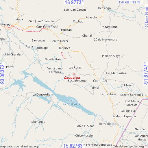
Zacualpa GPS coordinates[2]
16° 18' 13.068" North, 92° 22' 50.124" West
| Map corner | latitude | longitude |
|---|---|---|
| Upper-left | 16.9773°, | -93.08372° |
| Center: | 16.30363°, | -92.38059° |
| Lower-right: | 15.62763°, | -91.67747° |
| Map W x H: | 150.1×150.1 km | = 93.3×93.3mi |
| max Lat: | 32.7° ⇑95.6% North |
| Zacualpa: | 16.30363° |
| min Lat: | ⇓4.4% South 14.53588° |
| min Long | Zacualpa | max Long |
| -117.105° | -92.38059° | -86.73105° |
| W 92.9%⇐ | ⇒7.1% E |
Elevation
Elevation of Zacualpa is 1018 m = 3340 ft, and this is 235.7 m = 773 ft below average elevation for this country.
| Max E: |
3497 m = 11473 ft | 59.7% |
| Avg. | 1253.7 m = 4113 ft | |
| Zacualpa | 1018 m = 3340 ft | |
Min E: |
-1 m = -3 ft | 40.3% |
See also: Mexico elevation on elevation.city.
Geographical zone
Zacualpa is located in North Torrid zone (between Equator and Tropic of Cancer). Distance of this Northern Tropic circle is 793.1 km =492.8 mi to North.| Distance of | km | miles | from Zacualpa |
|---|---|---|---|
| North Pole | 8194.3 | 5091.7 | to North |
| Arctic Circle | 5588.4 | 3472.5 | to North |
| Tropic Cancer | 793.1 | 492.8 | to North |
| Equator | 1812.8 | 1126.4 | to South |


Nearby cities:
15 places around Zacualpa: (largest is in red/bold)
• Corral Hierba
6.6 km =4.1 mi,  316°
316°
• El Puerto
14.6 km =9.1 mi,  338°
338°
• Emiliano Zapata
13.9 km =8.6 mi,  195°
195°
• Francisco Villa
17 km =10.6 mi,  142°
142°
• Grandeza del Río Blanco
15.7 km =9.8 mi,  304°
304°
• Ixtapilla
8.5 km =5.3 mi, 321°
• La Gloria (La Tranca)
9.4 km =5.8 mi,  269°
269°
• Las Rosas
7 km =4.3 mi,  8°
8°
• Ochusjob
16.3 km =10.1 mi,  122°
122°
• San Francisco Pujiltic
8.2 km =5.1 mi,  250°
250°
• San Vicente la Mesilla
16.7 km =10.4 mi,  146°
146°
• Socoltenango
7.3 km =4.5 mi, 153°
• Soyatitán
4.8 km =3 mi,  257°
257°
• Tzinil
8 km =5 mi,  129°
129°
• Yaltzi Tres Lagunas
13 km =8.1 mi,  91°
91°
Sources, notices
• [Note1] Compared only with cities in Mexico existing in our database
• [Src1] Map data: © OpenStreetMap contributors (CC-BY-SA)
• [Src2] Other city data from geonames.org with taken over terms of usage.
• [Src3] Geographical zone / Annual Mean Temperature by Robert A. Rohde @ Wikipedia
