Soyatitán geodata
Soyatitán (Chiapas) is a populated place; located in Mexico in America/Mexico_City (GMT-6) time zone. With population of 3,904 people, there are 2341 cities with bigger population in this country. Compared to other cities in Mexico, 95.7% of cities are located further ↑North; 92.5% of cities are located further ←West and 62.5% of cities have higher elevation than Soyatitán. Note1


Soyatitán GPS coordinates[2]
16° 17' 39.372" North, 92° 25' 26.472" West
| Map corner | latitude | longitude |
|---|---|---|
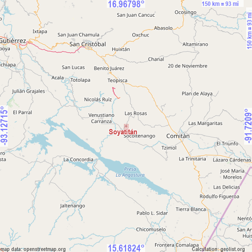
| Upper-left | 16.96798°, | -93.12715° |
| Center: | 16.29427°, | -92.42402° |
| Lower-right: | 15.61824°, | -91.7209° |
| Map W x H: | 150.1×150.1 km | = 93.3×93.3mi |
| max Lat: | 32.7° ⇑95.7% North |
| Soyatitán: | 16.29427° |
| min Lat: | ⇓4.3% South 14.53588° |
| min Long | Soyatitán | max Long |
| -117.105° | -92.42402° | -86.73105° |
| W 92.5%⇐ | ⇒7.5% E |
Elevation
Elevation of Soyatitán is 853 m = 2799 ft, and this is 400.7 m = 1315 ft below average elevation for this country.
| Max E: |
3497 m = 11473 ft | 62.5% |
| Avg. | 1253.7 m = 4113 ft | |
| Soyatitán | 853 m = 2799 ft | |
Min E: |
-1 m = -3 ft | 37.5% |
See also: Mexico elevation on elevation.city.
Geographical zone
Soyatitán is located in North Torrid zone (between Equator and Tropic of Cancer). Distance of this Northern Tropic circle is 794.2 km =493.5 mi to North.| Distance of | km | miles | from Soyatitán |
|---|---|---|---|
| North Pole | 8195.3 | 5092.3 | to North |
| Arctic Circle | 5589.4 | 3473.1 | to North |
| Tropic Cancer | 794.2 | 493.5 | to North |
| Equator | 1811.8 | 1125.8 | to South |


Nearby cities:
15 places around Soyatitán: (largest is in red/bold)
• Corral Hierba
5.8 km =3.6 mi,  1°
1°
• El Puerto
14.6 km =9.1 mi,  357°
357°
• Emiliano Zapata
12.4 km =7.7 mi,  176°
176°
• Grandeza del Río Blanco
12.9 km =8 mi,  320°
320°
• Guadalupe Victoria
18.4 km =11.4 mi,  311°
311°
• Ixtapilla
7.7 km =4.8 mi,  354°
354°
• La Gloria (La Tranca)
4.9 km =3 mi,  282°
282°
• Las Rosas
9.8 km =6.1 mi,  35°
35°
• San Francisco (El Calvito)
15 km =9.3 mi, 281°
• San Francisco Pujiltic
3.5 km =2.2 mi,  241°
241°
• Socoltenango
9.6 km =6 mi,  124°
124°
• Tzinil
11.6 km =7.2 mi,  110°
110°
• Venustiano Carranza
15.6 km =9.7 mi,  288°
288°
• Yaltzi Tres Lagunas
17.6 km =10.9 mi,  88°
88°
• Zacualpa
4.8 km =3 mi,  77°
77°
Sources, notices
• [Note1] Compared only with cities in Mexico existing in our database
• [Src1] Map data: © OpenStreetMap contributors (CC-BY-SA)
• [Src2] Other city data from geonames.org with taken over terms of usage.
• [Src3] Geographical zone / Annual Mean Temperature by Robert A. Rohde @ Wikipedia
