Xocotlán geodata
Xocotlán (State of Mexico) is a populated place; located in Mexico in America/Mexico_City (GMT-6) time zone. With population of 5,082 people, there are 1825 cities with bigger population in this country. Compared to other cities in Mexico, 53.7% of cities are located further ↑North; 52.9% of cities are located further ←West and 86.1% of cities have lower elevation than Xocotlán. Note1


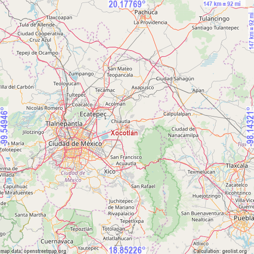
Xocotlán GPS coordinates[2]
19° 30' 58.788" North, 98° 50' 46.788" West
| Map corner | latitude | longitude |
|---|---|---|
| Upper-left | 20.17769°, | -99.54946° |
| Center: | 19.51633°, | -98.84633° |
| Lower-right: | 18.85226°, | -98.14321° |
| Map W x H: | 147.4×147.4 km | = 91.6×91.6mi |
| max Lat: | 32.7° ⇑53.7% North |
| Xocotlán: | 19.51633° |
| min Lat: | ⇓46.3% South 14.53588° |
| min Long | Xocotlán | max Long |
| -117.105° | -98.84633° | -86.73105° |
| W 52.9%⇐ | ⇒47.1% E |
Elevation
Elevation of Xocotlán is 2284 m = 7493 ft, and this is 1030.3 m = 3380 ft above average elevation for this country.
| Max E: |
3497 m = 11473 ft | 13.9% |
| Xocotlán | 2284 m 7493 ft | |
| Avg. | 1253.7 m = 4113 ft | |
Min E: |
-1 m = -3 ft | 86.1% |
See also: Mexico elevation on elevation.city.
Geographical zone
Xocotlán is located in North Torrid zone (between Equator and Tropic of Cancer). Distance of this Northern Tropic circle is 435.9 km =270.9 mi to North.| Distance of | km | miles | from Xocotlán |
|---|---|---|---|
| North Pole | 7837 | 4869.7 | to North |
| Arctic Circle | 5231.2 | 3250.5 | to North |
| Tropic Cancer | 435.9 | 270.9 | to North |
| Equator | 2170 | 1348.4 | to South |


Nearby cities:
15 places around Xocotlán: (largest is in red/bold)
• Atenguillo
6.1 km =3.8 mi,  329°
329°
• Chiautla
5.2 km =3.2 mi,  313°
313°
• Colonia Santiago
4.9 km =3 mi,  23°
23°
• Colonia Tulteca Teopan
5 km =3.1 mi,  2°
2°
• Colonia Villas de Tolimpa
6.1 km =3.8 mi,  220°
220°
• Colonia las Tijeras
6.4 km =4 mi,  202°
202°
• Ejido San Cristóbal
5.8 km =3.6 mi,  300°
300°
• La Purificación
3.2 km =2 mi,  73°
73°
• Papalotla
5.3 km =3.3 mi,  348°
348°
• San Joaquín Coapango
3.3 km =2.1 mi,  36°
36°
• San Miguel Tlaixpan
3.8 km =2.4 mi,  101°
101°
• Tequexquináhuac
4.9 km =3 mi,  152°
152°
• Texcoco de Mora
3.9 km =2.4 mi,  262°
262°
• Tulantongo
3.4 km =2.1 mi, 299°
• Xochimanca
3.7 km =2.3 mi,  141°
141°
Sources, notices
• [Note1] Compared only with cities in Mexico existing in our database
• [Src1] Map data: © OpenStreetMap contributors (CC-BY-SA)
• [Src2] Other city data from geonames.org with taken over terms of usage.
• [Src3] Geographical zone / Annual Mean Temperature by Robert A. Rohde @ Wikipedia
