San Bartolo geodata
San Bartolo (State of Mexico) is a populated place; located in Mexico in America/Mexico_City (GMT-6) time zone. With population of 5,099 people, there are 1816 cities with bigger population in this country. Compared to other cities in Mexico, 50.7% of cities are located further ↑North; 51.9% of cities are located further ←West and 85.2% of cities have lower elevation than San Bartolo. Note1


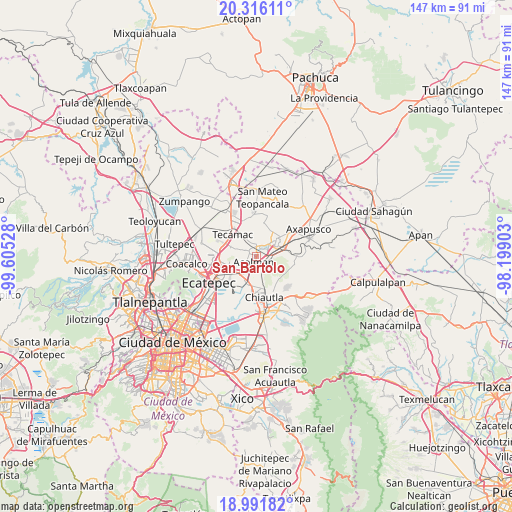
San Bartolo GPS coordinates[2]
19° 39' 19.188" North, 98° 54' 7.74" West
| Map corner | latitude | longitude |
|---|---|---|
| Upper-left | 20.31611°, | -99.60528° |
| Center: | 19.65533°, | -98.90215° |
| Lower-right: | 18.99182°, | -98.19903° |
| Map W x H: | 147.2×147.2 km | = 91.5×91.5mi |
| max Lat: | 32.7° ⇑50.7% North |
| San Bartolo: | 19.65533° |
| min Lat: | ⇓49.3% South 14.53588° |
| min Long | San Bartolo | max Long |
| -117.105° | -98.90215° | -86.73105° |
| W 51.9%⇐ | ⇒48.1% E |
Elevation
Elevation of San Bartolo is 2263 m = 7425 ft, and this is 1009.3 m = 3311 ft above average elevation for this country.
| Max E: |
3497 m = 11473 ft | 14.8% |
| San Bartolo | 2263 m 7425 ft | |
| Avg. | 1253.7 m = 4113 ft | |
Min E: |
-1 m = -3 ft | 85.2% |
See also: Mexico elevation on elevation.city.
Geographical zone
San Bartolo is located in North Torrid zone (between Equator and Tropic of Cancer). Distance of this Northern Tropic circle is 420.5 km =261.3 mi to North.| Distance of | km | miles | from San Bartolo |
|---|---|---|---|
| North Pole | 7821.6 | 4860.1 | to North |
| Arctic Circle | 5215.7 | 3240.9 | to North |
| Tropic Cancer | 420.5 | 261.3 | to North |
| Equator | 2185.5 | 1358 | to South |


Nearby cities:
15 places around San Bartolo: (largest is in red/bold)
• Acolman de Netzahualcóyotl
1.8 km =1.1 mi,  198°
198°
• Atlatongo
1.4 km =0.9 mi,  351°
351°
• Ejido Atlatongo
2 km =1.2 mi,  358°
358°
• El Potrero (Ejido Purificación)
3.8 km =2.4 mi,  54°
54°
• San José
0.9 km =0.6 mi,  300°
300°
• San Lorenzo Tlalmimilolpan
3.4 km =2.1 mi,  66°
66°
• San Lucas Tepango
4.5 km =2.8 mi,  103°
103°
• San Marcos Nepantla
3.5 km =2.2 mi, 296°
• San Pedro Tepetitlán
3.3 km =2.1 mi,  154°
154°
• Santa Catarina
3.3 km =2.1 mi,  230°
230°
• Santiago Zacualuca
5.7 km =3.5 mi,  330°
330°
• Teotihuacán
5.7 km =3.5 mi, 49°
• Teotihuacán de Arista
5.8 km =3.6 mi, 48°
• Tepexpan
5.8 km =3.6 mi,  217°
217°
• Xometla
2.6 km =1.6 mi,  123°
123°
Sources, notices
• [Note1] Compared only with cities in Mexico existing in our database
• [Src1] Map data: © OpenStreetMap contributors (CC-BY-SA)
• [Src2] Other city data from geonames.org with taken over terms of usage.
• [Src3] Geographical zone / Annual Mean Temperature by Robert A. Rohde @ Wikipedia
