San Marcos Nepantla geodata
San Marcos Nepantla (State of Mexico) is a populated place; located in Mexico in America/Mexico_City (GMT-6) time zone. With population of 4,116 people, there are 2224 cities with bigger population in this country. Compared to other cities in Mexico, 50.4% of cities are located further ↑North; 51.4% of cities are located further ←West and 86.4% of cities have lower elevation than San Marcos Nepantla. Note1


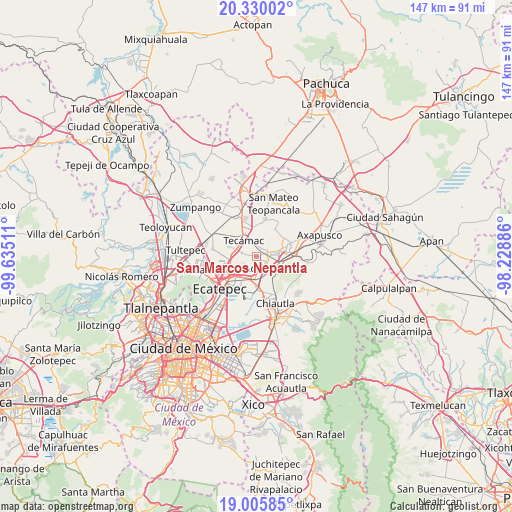
San Marcos Nepantla GPS coordinates[2]
19° 40' 9.48" North, 98° 55' 55.128" West
| Map corner | latitude | longitude |
|---|---|---|
| Upper-left | 20.33002°, | -99.63511° |
| Center: | 19.6693°, | -98.93198° |
| Lower-right: | 19.00585°, | -98.22886° |
| Map W x H: | 147.2×147.2 km | = 91.5×91.5mi |
| max Lat: | 32.7° ⇑50.4% North |
| San Marcos Nepantla: | 19.6693° |
| min Lat: | ⇓49.6% South 14.53588° |
| min Long | San Marcos Nepa | max Long |
| -117.105° | -98.93198° | -86.73105° |
| W 51.4%⇐ | ⇒48.6% E |
Elevation
Elevation of San Marcos Nepantla is 2292 m = 7520 ft, and this is 1038.3 m = 3406 ft above average elevation for this country.
| Max E: |
3497 m = 11473 ft | 13.6% |
| San Marcos Nepantla | 2292 m 7520 ft | |
| Avg. | 1253.7 m = 4113 ft | |
Min E: |
-1 m = -3 ft | 86.4% |
See also: Mexico elevation on elevation.city.
Geographical zone
San Marcos Nepantla is located in North Torrid zone (between Equator and Tropic of Cancer). Distance of this Northern Tropic circle is 418.9 km =260.3 mi to North.| Distance of | km | miles | from San Marcos Nepantla |
|---|---|---|---|
| North Pole | 7820 | 4859.1 | to North |
| Arctic Circle | 5214.2 | 3240 | to North |
| Tropic Cancer | 418.9 | 260.3 | to North |
| Equator | 2187 | 1358.9 | to South |


Nearby cities:
15 places around San Marcos Nepantla: (largest is in red/bold)
• Acolman de Netzahualcóyotl
4.1 km =2.5 mi,  142°
142°
• Atlatongo
2.9 km =1.8 mi,  93°
93°
• Ejido Atlatongo
3.1 km =1.9 mi,  81°
81°
• El Potrero (Ejido Purificación)
6.2 km =3.9 mi, 83°
• Prados de San Juan
5.6 km =3.5 mi,  234°
234°
• San Bartolo
3.5 km =2.2 mi,  116°
116°
• San Isidro del Progreso
4.8 km =3 mi,  21°
21°
• San José
2.6 km =1.6 mi, 115°
• San Martín Azcatepec
4.7 km =2.9 mi,  294°
294°
• San Pablo Tecalco
2.8 km =1.7 mi,  278°
278°
• Santa Catarina
3.7 km =2.3 mi,  171°
171°
• Santiago Zacualuca
3.5 km =2.2 mi,  5°
5°
• Tecámac
6.2 km =3.9 mi,  321°
321°
• Tepexpan
6.2 km =3.9 mi,  184°
184°
• Xometla
6 km =3.7 mi, 119°
Sources, notices
• [Note1] Compared only with cities in Mexico existing in our database
• [Src1] Map data: © OpenStreetMap contributors (CC-BY-SA)
• [Src2] Other city data from geonames.org with taken over terms of usage.
• [Src3] Geographical zone / Annual Mean Temperature by Robert A. Rohde @ Wikipedia
