Progreso de Allende geodata
Progreso de Allende (Puebla) is a populated place; located in Mexico in America/Mexico_City (GMT-6) time zone. With population of 533 people, there are 15888 cities with bigger population in this country. Compared to other cities in Mexico, 70.4% of cities are located further ↓South; 64.9% of cities are located further ←West and 76.8% of cities have higher elevation than Progreso de Allende. Note1


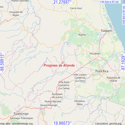
Progreso de Allende GPS coordinates[2]
20° 37' 12.792" North, 97° 53' 45.672" West
| Map corner | latitude | longitude |
|---|---|---|
| Upper-left | 21.27687°, | -98.59915° |
| Center: | 20.62022°, | -97.89602° |
| Lower-right: | 19.96073°, | -97.1929° |
| Map W x H: | 146.3×146.3 km | = 90.9×90.9mi |
| max Lat: | 32.7° ⇑29.6% North |
| Progreso de Allende: | 20.62022° |
| min Lat: | ⇓70.4% South 14.53588° |
| min Long | Progreso de All | max Long |
| -117.105° | -97.89602° | -86.73105° |
| W 64.9%⇐ | ⇒35.1% E |
Elevation
Elevation of Progreso de Allende is 158 m = 518 ft, and this is 1095.7 m = 3595 ft below average elevation for this country.
| Max E: |
3497 m = 11473 ft | 76.8% |
| Avg. | 1253.7 m = 4113 ft | |
| Progreso de Allende | 158 m = 518 ft | |
Min E: |
-1 m = -3 ft | 23.2% |
See also: Mexico elevation on elevation.city.
Geographical zone
Progreso de Allende is located in North Torrid zone (between Equator and Tropic of Cancer). Distance of this Northern Tropic circle is 313.2 km =194.6 mi to North.| Distance of | km | miles | from Progreso de Allende |
|---|---|---|---|
| North Pole | 7714.3 | 4793.4 | to North |
| Arctic Circle | 5108.4 | 3174.2 | to North |
| Tropic Cancer | 313.2 | 194.6 | to North |
| Equator | 2292.8 | 1424.7 | to South |


Nearby cities:
15 places around Progreso de Allende: (largest is in red/bold)
• Agua Linda
4.9 km =3 mi,  140°
140°
• Ameluca
9.7 km =6 mi,  130°
130°
• Ejido Carrizal Viejo
11 km =6.8 mi,  170°
170°
• Ejido Cañada Colotla
6.5 km =4 mi,  201°
201°
• El Tepetate
5.3 km =3.3 mi,  214°
214°
• El Zapote Bravo
11.7 km =7.3 mi,  293°
293°
• Ixtololoya
12.9 km =8 mi, 213°
• Jaltocan
8.1 km =5 mi,  90°
90°
• La Pahua
4.5 km =2.8 mi,  101°
101°
• Mecapalapa
11.2 km =7 mi,  158°
158°
• Moctezuma
12.7 km =7.9 mi,  42°
42°
• Ojital Cuayo
12 km =7.5 mi,  326°
326°
• Pantepec
11.8 km =7.3 mi, 202°
• Pisaflores
3.5 km =2.2 mi,  250°
250°
• San Martín
9.4 km =5.8 mi, 332°
Sources, notices
• [Note1] Compared only with cities in Mexico existing in our database
• [Src1] Map data: © OpenStreetMap contributors (CC-BY-SA)
• [Src2] Other city data from geonames.org with taken over terms of usage.
• [Src3] Geographical zone / Annual Mean Temperature by Robert A. Rohde @ Wikipedia
