El Tepetate geodata
El Tepetate (Veracruz) is a populated place; located in Mexico in America/Mexico_City (GMT-6) time zone. With population of 529 people, there are 15998 cities with bigger population in this country. Compared to other cities in Mexico, 69.6% of cities are located further ↓South; 64.5% of cities are located further ←West and 75.7% of cities have higher elevation than El Tepetate. Note1


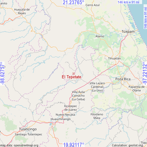
El Tepetate GPS coordinates[2]
20° 34' 50.988" North, 97° 55' 27.984" West
| Map corner | latitude | longitude |
|---|---|---|
| Upper-left | 21.23765°, | -98.62757° |
| Center: | 20.58083°, | -97.92444° |
| Lower-right: | 19.92117°, | -97.22132° |
| Map W x H: | 146.4×146.4 km | = 91×91mi |
| max Lat: | 32.7° ⇑30.4% North |
| El Tepetate: | 20.58083° |
| min Lat: | ⇓69.6% South 14.53588° |
| min Long | El Tepetate | max Long |
| -117.105° | -97.92444° | -86.73105° |
| W 64.5%⇐ | ⇒35.5% E |
Elevation
Elevation of El Tepetate is 198 m = 650 ft, and this is 1055.7 m = 3464 ft below average elevation for this country.
| Max E: |
3497 m = 11473 ft | 75.7% |
| Avg. | 1253.7 m = 4113 ft | |
| El Tepetate | 198 m = 650 ft | |
Min E: |
-1 m = -3 ft | 24.3% |
See also: Mexico elevation on elevation.city.
Geographical zone
El Tepetate is located in North Torrid zone (between Equator and Tropic of Cancer). Distance of this Northern Tropic circle is 317.5 km =197.3 mi to North.| Distance of | km | miles | from El Tepetate |
|---|---|---|---|
| North Pole | 7718.7 | 4796.2 | to North |
| Arctic Circle | 5112.8 | 3176.9 | to North |
| Tropic Cancer | 317.5 | 197.3 | to North |
| Equator | 2288.4 | 1421.9 | to South |


Nearby cities:
15 places around El Tepetate: (largest is in red/bold)
• Agua Linda
6.1 km =3.8 mi,  84°
84°
• Ameluca
10.5 km =6.5 mi,  100°
100°
• Ejido Carrizal Viejo
8.1 km =5 mi,  143°
143°
• Ejido Cañada Colotla
1.7 km =1.1 mi,  159°
159°
• El Pozo
8.9 km =5.5 mi,  214°
214°
• Ixtololoya
7.6 km =4.7 mi, 213°
• Juntas Chicas
11.1 km =6.9 mi,  266°
266°
• La Pahua
8.1 km =5 mi,  64°
64°
• Mecapalapa
9.3 km =5.8 mi,  130°
130°
• Nuevo Carrizal
9.4 km =5.8 mi, 161°
• Pantepec
6.7 km =4.2 mi,  192°
192°
• Pisaflores
3.2 km =2 mi,  353°
353°
• Progreso de Allende
5.3 km =3.3 mi,  34°
34°
• San Francisco
8.7 km =5.4 mi,  248°
248°
• Vista Hermosa
11 km =6.8 mi,  167°
167°
Sources, notices
• [Note1] Compared only with cities in Mexico existing in our database
• [Src1] Map data: © OpenStreetMap contributors (CC-BY-SA)
• [Src2] Other city data from geonames.org with taken over terms of usage.
• [Src3] Geographical zone / Annual Mean Temperature by Robert A. Rohde @ Wikipedia
