Ixtololoya geodata
Ixtololoya (Puebla) is a populated place; located in Mexico in America/Mexico_City (GMT-6) time zone. With population of 689 people, there are 12616 cities with bigger population in this country. Compared to other cities in Mexico, 68.3% of cities are located further ↓South; 64% of cities are located further ←West and 69% of cities have higher elevation than Ixtololoya. Note1


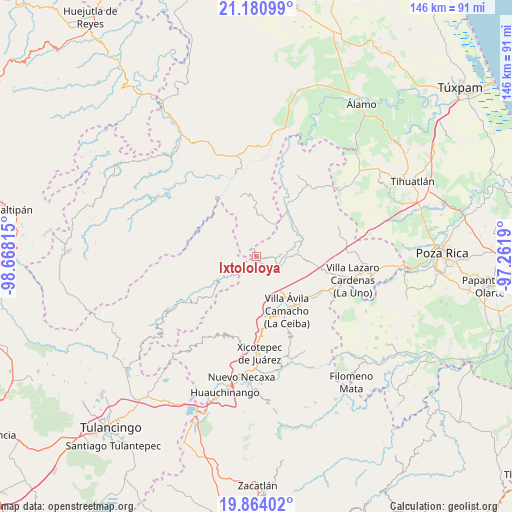
Ixtololoya GPS coordinates[2]
20° 31' 26.112" North, 97° 57' 54.072" West
| Map corner | latitude | longitude |
|---|---|---|
| Upper-left | 21.18099°, | -98.66815° |
| Center: | 20.52392°, | -97.96502° |
| Lower-right: | 19.86402°, | -97.2619° |
| Map W x H: | 146.4×146.4 km | = 91×91mi |
| max Lat: | 32.7° ⇑31.7% North |
| Ixtololoya: | 20.52392° |
| min Lat: | ⇓68.3% South 14.53588° |
| min Long | Ixtololoya | max Long |
| -117.105° | -97.96502° | -86.73105° |
| W 64%⇐ | ⇒36% E |
Elevation
Elevation of Ixtololoya is 468 m = 1535 ft, and this is 785.7 m = 2578 ft below average elevation for this country.
| Max E: |
3497 m = 11473 ft | 69% |
| Avg. | 1253.7 m = 4113 ft | |
| Ixtololoya | 468 m = 1535 ft | |
Min E: |
-1 m = -3 ft | 31% |
See also: Mexico elevation on elevation.city.
Geographical zone
Ixtololoya is located in North Torrid zone (between Equator and Tropic of Cancer). Distance of this Northern Tropic circle is 323.9 km =201.3 mi to North.| Distance of | km | miles | from Ixtololoya |
|---|---|---|---|
| North Pole | 7725 | 4800.1 | to North |
| Arctic Circle | 5119.1 | 3180.9 | to North |
| Tropic Cancer | 323.9 | 201.3 | to North |
| Equator | 2282 | 1418 | to South |


Nearby cities:
15 places around Ixtololoya: (largest is in red/bold)
• Acuautla
8.1 km =5 mi,  242°
242°
• Ejido Carrizal Viejo
9 km =5.6 mi,  91°
91°
• Ejido Cañada Colotla
6.7 km =4.2 mi,  45°
45°
• Ejido de Jalpan
9.1 km =5.7 mi,  141°
141°
• El Pozo
1.3 km =0.8 mi,  218°
218°
• El Tepetate
7.6 km =4.7 mi,  33°
33°
• Juntas Chicas
8.8 km =5.5 mi,  309°
309°
• Nuevo Carrizal
7.7 km =4.8 mi,  109°
109°
• Pantepec
2.8 km =1.7 mi, 94°
• Pisaflores
10.3 km =6.4 mi,  22°
22°
• San Ambrosio
5.9 km =3.7 mi,  274°
274°
• San Esteban
10.2 km =6.3 mi,  283°
283°
• San Francisco
5 km =3.1 mi, 309°
• San Gregorio
6.2 km =3.9 mi, 242°
• Vista Hermosa
7.9 km =4.9 mi,  123°
123°
Sources, notices
• [Note1] Compared only with cities in Mexico existing in our database
• [Src1] Map data: © OpenStreetMap contributors (CC-BY-SA)
• [Src2] Other city data from geonames.org with taken over terms of usage.
• [Src3] Geographical zone / Annual Mean Temperature by Robert A. Rohde @ Wikipedia
