Ahuacatlán geodata
Ahuacatlán (Puebla) is a populated place; located in Mexico in America/Mexico_City (GMT-6) time zone. With population of 1,540 people, there are 5608 cities with bigger population in this country. Compared to other cities in Mexico, 54.8% of cities are located further ↓South; 69% of cities are located further ←West and 77.5% of cities have lower elevation than Ahuacatlán. Note1


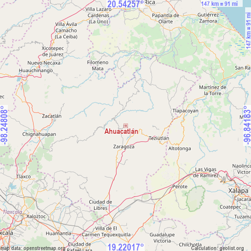
Ahuacatlán GPS coordinates[2]
19° 52' 57.9" North, 97° 32' 41.82" West
| Map corner | latitude | longitude |
|---|---|---|
| Upper-left | 20.54257°, | -98.24808° |
| Center: | 19.88275°, | -97.54495° |
| Lower-right: | 19.22017°, | -96.84183° |
| Map W x H: | 147×147 km | = 91.3×91.3mi |
| max Lat: | 32.7° ⇑45.2% North |
| Ahuacatlán: | 19.88275° |
| min Lat: | ⇓54.8% South 14.53588° |
| min Long | Ahuacatlán | max Long |
| -117.105° | -97.54495° | -86.73105° |
| W 69%⇐ | ⇒31% E |
Elevation
Elevation of Ahuacatlán is 2079 m = 6821 ft, and this is 825.3 m = 2708 ft above average elevation for this country.
| Max E: |
3497 m = 11473 ft | 22.5% |
| Ahuacatlán | 2079 m 6821 ft | |
| Avg. | 1253.7 m = 4113 ft | |
Min E: |
-1 m = -3 ft | 77.5% |
See also: Mexico elevation on elevation.city.
Geographical zone
Ahuacatlán is located in North Torrid zone (between Equator and Tropic of Cancer). Distance of this Northern Tropic circle is 395.2 km =245.6 mi to North.| Distance of | km | miles | from Ahuacatlán |
|---|---|---|---|
| North Pole | 7796.3 | 4844.4 | to North |
| Arctic Circle | 5190.4 | 3225.2 | to North |
| Tropic Cancer | 395.2 | 245.6 | to North |
| Equator | 2210.8 | 1373.7 | to South |


Nearby cities:
15 places around Ahuacatlán: (largest is in red/bold)
• Atalpa
5.4 km =3.4 mi,  126°
126°
• Atalpan
4.6 km =2.9 mi,  200°
200°
• Cohuatzalpan
2.9 km =1.8 mi,  297°
297°
• Cuacuilco
3.5 km =2.2 mi,  177°
177°
• El Progreso
1.6 km =1 mi,  6°
6°
• Huaxtla
5.9 km =3.7 mi, 133°
• Los Cristales (Talican)
5.3 km =3.3 mi,  257°
257°
• San Francisco Zacapexpan
5.4 km =3.4 mi,  267°
267°
• Santa Cruz Xaltetela
3.9 km =2.4 mi, 255°
• Tatoxcac
3.3 km =2.1 mi,  243°
243°
• Tatzecuala
1.7 km =1.1 mi,  151°
151°
• Xalacapan de Lucke
5.3 km =3.3 mi, 296°
• Xilita
6 km =3.7 mi,  315°
315°
• Xochitepec
4.5 km =2.8 mi,  340°
340°
• Zacapoaxtla
4.7 km =2.9 mi, 256°
Sources, notices
• [Note1] Compared only with cities in Mexico existing in our database
• [Src1] Map data: © OpenStreetMap contributors (CC-BY-SA)
• [Src2] Other city data from geonames.org with taken over terms of usage.
• [Src3] Geographical zone / Annual Mean Temperature by Robert A. Rohde @ Wikipedia
