Xalacapan de Lucke geodata
Xalacapan de Lucke (Puebla) is a populated place; located in Mexico in America/Mexico_City (GMT-6) time zone. With population of 4,398 people, there are 2086 cities with bigger population in this country. Compared to other cities in Mexico, 55.1% of cities are located further ↓South; 68.5% of cities are located further ←West and 56.3% of cities have lower elevation than Xalacapan de Lucke. Note1


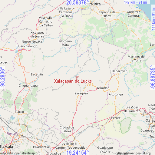
Xalacapan de Lucke GPS coordinates[2]
19° 54' 14.508" North, 97° 35' 25.692" West
| Map corner | latitude | longitude |
|---|---|---|
| Upper-left | 20.56376°, | -98.2936° |
| Center: | 19.90403°, | -97.59047° |
| Lower-right: | 19.24154°, | -96.88735° |
| Map W x H: | 147×147 km | = 91.3×91.3mi |
| max Lat: | 32.7° ⇑44.9% North |
| Xalacapan de Lucke: | 19.90403° |
| min Lat: | ⇓55.1% South 14.53588° |
| min Long | Xalacapan de Lu | max Long |
| -117.105° | -97.59047° | -86.73105° |
| W 68.5%⇐ | ⇒31.5% E |
Elevation
Elevation of Xalacapan de Lucke is 1631 m = 5351 ft, and this is 377.3 m = 1238 ft above average elevation for this country.
| Max E: |
3497 m = 11473 ft | 43.7% |
| Xalacapan de Lucke | 1631 m 5351 ft | |
| Avg. | 1253.7 m = 4113 ft | |
Min E: |
-1 m = -3 ft | 56.3% |
See also: Mexico elevation on elevation.city.
Geographical zone
Xalacapan de Lucke is located in North Torrid zone (between Equator and Tropic of Cancer). Distance of this Northern Tropic circle is 392.8 km =244.1 mi to North.| Distance of | km | miles | from Xalacapan de Lucke |
|---|---|---|---|
| North Pole | 7793.9 | 4842.9 | to North |
| Arctic Circle | 5188.1 | 3223.7 | to North |
| Tropic Cancer | 392.8 | 244.1 | to North |
| Equator | 2213.1 | 1375.2 | to South |


Nearby cities:
15 places around Xalacapan de Lucke: (largest is in red/bold)
• Ahuacatlán
5.3 km =3.3 mi,  116°
116°
• Cohuatzalpan
2.4 km =1.5 mi, 115°
• Comaltepec
5.1 km =3.2 mi,  190°
190°
• El Progreso
5 km =3.1 mi,  99°
99°
• Huahuaxtla
5.1 km =3.2 mi,  285°
285°
• Los Cristales (Talican)
3.5 km =2.2 mi, 186°
• San Francisco Zacapexpan
2.7 km =1.7 mi, 192°
• San Juan Tahitic
5.5 km =3.4 mi,  49°
49°
• San Rafael Axolota
4.4 km =2.7 mi,  336°
336°
• Santa Cruz Xaltetela
3.5 km =2.2 mi,  163°
163°
• Tatoxcac
4.3 km =2.7 mi,  154°
154°
• Xilita
1.9 km =1.2 mi,  16°
16°
• Xochitepec
3.7 km =2.3 mi,  60°
60°
• Zacapoaxtla
3.5 km =2.2 mi,  177°
177°
• Zoatecpan
4.6 km =2.9 mi,  317°
317°
Sources, notices
• [Note1] Compared only with cities in Mexico existing in our database
• [Src1] Map data: © OpenStreetMap contributors (CC-BY-SA)
• [Src2] Other city data from geonames.org with taken over terms of usage.
• [Src3] Geographical zone / Annual Mean Temperature by Robert A. Rohde @ Wikipedia
