Venustiano Carranza geodata
Venustiano Carranza (Puebla) is a populated place; located in Mexico in America/Mexico_City (GMT-6) time zone. With population of 713 people, there are 12219 cities with bigger population in this country. Compared to other cities in Mexico, 60.5% of cities are located further ↑North; 69.7% of cities are located further ←West and 90% of cities have lower elevation than Venustiano Carranza. Note1


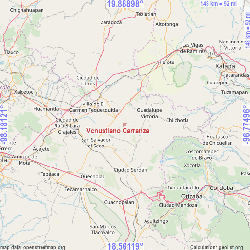
Venustiano Carranza GPS coordinates[2]
19° 13' 35.148" North, 97° 28' 41.088" West
| Map corner | latitude | longitude |
|---|---|---|
| Upper-left | 19.88898°, | -98.18121° |
| Center: | 19.22643°, | -97.47808° |
| Lower-right: | 18.56119°, | -96.77496° |
| Map W x H: | 147.6×147.6 km | = 91.7×91.7mi |
| max Lat: | 32.7° ⇑60.5% North |
| Venustiano Carranza: | 19.22643° |
| min Lat: | ⇓39.5% South 14.53588° |
| min Long | Venustiano Carr | max Long |
| -117.105° | -97.47808° | -86.73105° |
| W 69.7%⇐ | ⇒30.3% E |
Elevation
Elevation of Venustiano Carranza is 2406 m = 7894 ft, and this is 1152.3 m = 3781 ft above average elevation for this country.
| Max E: |
3497 m = 11473 ft | 10% |
| Venustiano Carranza | 2406 m 7894 ft | |
| Avg. | 1253.7 m = 4113 ft | |
Min E: |
-1 m = -3 ft | 90% |
See also: Mexico elevation on elevation.city.
Geographical zone
Venustiano Carranza is located in North Torrid zone (between Equator and Tropic of Cancer). Distance of this Northern Tropic circle is 468.1 km =290.9 mi to North.| Distance of | km | miles | from Venustiano Carranza |
|---|---|---|---|
| North Pole | 7869.3 | 4889.8 | to North |
| Arctic Circle | 5263.4 | 3270.5 | to North |
| Tropic Cancer | 468.1 | 290.9 | to North |
| Equator | 2137.8 | 1328.4 | to South |


Nearby cities:
15 places around Venustiano Carranza: (largest is in red/bold)
• Emancipación Quetzalapa
10.8 km =6.7 mi,  123°
123°
• Emilio Portes Gil
9.6 km =6 mi,  339°
339°
• Guadalupe Libertad
10.4 km =6.5 mi,  114°
114°
• Hacienda Nueva (San Pedro el Águila)
13.8 km =8.6 mi,  29°
29°
• José María Morelos
9.5 km =5.9 mi,  173°
173°
• Lázaro Cárdenas
12.3 km =7.6 mi,  138°
138°
• Miguel Hidalgo
4.8 km =3 mi,  242°
242°
• Nuevo Centro de Población Tlachichuca
11.4 km =7.1 mi,  303°
303°
• Rafael Avila Camacho
13.1 km =8.1 mi,  148°
148°
• San José la Capilla
10.4 km =6.5 mi,  91°
91°
• San Nicolas Buenos Aires
10.3 km =6.4 mi,  228°
228°
• Santa Cecilia Tepetitlán
6 km =3.7 mi,  129°
129°
• Santa Inés Varela la Luz
12.3 km =7.6 mi, 130°
• Zacatepec
7.3 km =4.5 mi,  307°
307°
• Álamos Tepetitlán
5.3 km =3.3 mi, 129°
Sources, notices
• [Note1] Compared only with cities in Mexico existing in our database
• [Src1] Map data: © OpenStreetMap contributors (CC-BY-SA)
• [Src2] Other city data from geonames.org with taken over terms of usage.
• [Src3] Geographical zone / Annual Mean Temperature by Robert A. Rohde @ Wikipedia
